| ARG - ARGENTINA | |||||||||||||||||
| CAPILLA DEL MONTE | |||||||||||||||||
| Description | Road circuit used for Touring Car races. Surface was partially asphalted (on National Road N°38) and partially in grit and dirt track | ||||||||||||||||
| Location | Capilla del Monte X - Córdoba - Centro | ||||||||||||||||
| Location | |||||||||||||||||
| Latitude - Longitude (approx) | - 30°50'51" - 64°33'08" (approx) -30.8475 -64.552222 (approx) | ||||||||||||||||
| UTM Coordinates (approx) | X = 351571.512 - Y = 6586267.612 - Zone 20J (approx) | ||||||||||||||||
| Aerial photo / Map (*) |  OpenStreetMap - Google Maps - Bing Maps - Flash Earth - Wikimapia OpenStreetMap - Google Maps - Bing Maps - Flash Earth - Wikimapia | ||||||||||||||||
| Altitude AMSL (approx) | 1000 m - 3281 ft (approx) | ||||||||||||||||
| Inauguration | 1964 | ||||||||||||||||
| Closing | August 2nd 1970 | ||||||||||||||||
| Designer | |||||||||||||||||
| Sources and links (Translation) (**) |
| ||||||||||||||||
| Capilla del Monte | |||||
| Description | |||||
| Years | 1964÷1967 | ||||
| Direction |  Anticlockwise Anticlockwise | ||||
 Proposal Proposal |
NO | ||||
| No longer operational | YES | ||||
| Car Circuit | YES | ||||
| Motorbike circuit | |||||
| Type | Road course | ||||
| Inauguration | 1964 | ||||
| Closing | 1967 | ||||
| Last update of this page | November 10th 2009 | ||||
| Info last update | |||||
| Designer | |||||
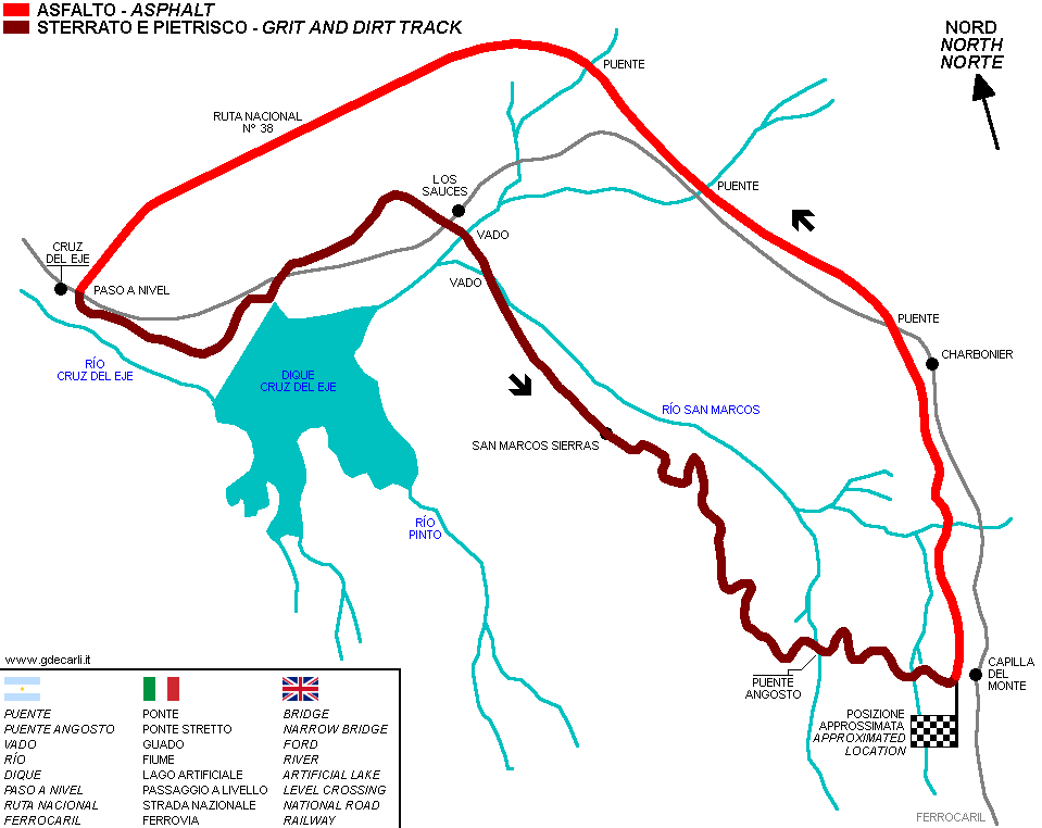
| Distinctive points | Capilla del Monte - Ruta Nacional N°38 - Charbonnier - Cruz del Eje - Los Sauces - San Marcos Sierra - Capilla del Monte | ||||
| Capilla del Monte | |||||
| Description | Track layout is very similar to the one used on previous years. The only difference is near Los Sauces, where the previous ford is replaces by a new wider section, on the right | ||||
| Years | 1968 | ||||
| Direction | Anticlockwise | ||||
| Proposal |
NO | ||||
| No longer operational | YES | ||||
| Car Circuit | YES | ||||
| Motorbike circuit | |||||
| Type | Road course | ||||
| Inauguration | April 14th 1968 | ||||
| Closing | April 14th 1968 | ||||
| Last update of this page | November 10th 2009 | ||||
| Info last update | |||||
| Designer | |||||
| Distinctive points | Capilla del Monte - Ruta Nacional N°38 - Charbonnier - Cruz del Eje - Los Sauces - San Marcos Sierra - Capilla del Monte | ||||
| length | 47.2 km | 29.33 mi | asphalted sections only | (1) | |
| length | 38.2 km | 23.737 mi | dirt sections only | (1) | |
| length | 85.4 km | 53.067 mi | Total length | (1) | |
| Capilla del Monte | |||||
| Description | 1970 track layout was a short version of the previous one. Section removed probably was the one near Cruz del Eje and its artificial lake | ||||
| Years | 1970 | ||||
| Direction | |||||
| Proposal |
NO | ||||
| No longer operational | YES | ||||
| Car Circuit | YES | ||||
| Motorbike circuit | |||||
| Type | Road course | ||||
| Inauguration | August 2nd 1970 | ||||
| Closing | August 2nd 1970 | ||||
| Last update of this page | November 10th 2009 | ||||
| Info last update | |||||
| Designer | |||||
| Distinctive points | |||||
| length | 30000 m | 98425 ft | 18.642 mi | asphalted sections only | (1) |
| length | 36.6 km | 22.743 mi | dirt sections only | (1) | |
| length | 66 km | 41.012 mi | Total length | (3) | |
| length | 66.6 km | 41.384 mi | Total length | (1) | |
Capilla del Monte 1968
| Updates | |||||||
| Date | Track layout | Years | Description by | Map by | Thanks to | Note | |
| November 11th 2009 | Guido de Carli | Guido de Carli | Luis Alberto González | Update | Description with map | ||
| Not all eventual updates issued in last years are already visible in this list | |||||||


