| ESP - SPAIN | |||||
| TENERIFE (1968) | |||||
| SORRY, SOME DATA ARE NOT TRANSLATED YET | |||||
| Not to be confused with | Puerto de la Cruz (Ciudad Turística) - Santa Cruz de Tenerife (1968) - Santa Cruz de Tenerife (CEPSA-Ofra) - Tenerife (2006) | ||||
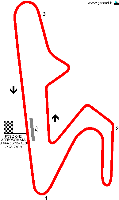
| Description | Permanent circuit designed by Sandro Rocci (who had already worked at Jarama), to be built in a mountainous area in Isle of Tenerife. Because of its climate, it would have been a perfect circuit to be used in winter, for tests and hypotetic races similar to Tasman Cup in Australia. Section between point 2 and 3 (see on the map) would have been flat, while other section are undulating: main straight starts downhill, section in front of pits is flat and it ends slightly uphill. After point 1 the uphill is harder. If some more ground would have been available, first bend could have been even wider. Inauguration was scheduled before end of 1969. It was never been built. | ||||
| Location | (Tenerife) TF - Santa Cruz de Tenerife - Canarias | ||||
| Location | |||||
| Latitude - Longitude (approx) | + 28°16'00" - 16°40'00" (approx) 28.266667 -16.666667 (approx) | ||||
| UTM Coordinates (approx) | X = 336521.471 - Y = 3127869.241 - Zone 28R (approx) | ||||
| Aerial photo / Map (*) |  OpenStreetMap - OpenStreetMap -  Google Maps - Google Maps -  Bing Maps - Bing Maps -  Flash Earth - Flash Earth -  Wikimapia - Wikimapia -  Visor SIGPAC Visor SIGPAC | ||||
| Altitude AMSL | |||||
| Inauguration | |||||
| Closing | |||||
| Designer | Rocci Sandro Rocci | ||||
| Sources and links (Translation) (**) |
| ||||
| Tenerife (1968) | |||||
| Description | |||||
| Years | 1968 | ||||
| Direction |  Anticlockwise Anticlockwise | ||||
 Proposal Proposal |
 YES YES
| ||||
| Proposal not developed | YES | ||||
| Car Circuit | YES | ||||
| Motorbike circuit | |||||
| Type | Permanent | ||||
| Inauguration | |||||
| Closing | |||||
| Last update of this page | April 15th 2006 | ||||
| Info last update | May 1968 | ||||
| Designer | |||||
| Distinctive points | |||||
| length | 4100 m | 13451 ft | 2.548 mi | (1) | |
Tenerife (1968)

| Updates | |||||||
| Date | Track layout | Years | Description by | Map by | Thanks to | Note | |
| April 15th 2006 | 1968 | Guido de Carli | Guido de Carli | New | Description with map | ||
| Not all eventual updates issued in last years are already visible in this list | |||||||
