| ESP - SPAIN | |||||||||||||||||||||
| MASPALOMAS | |||||||||||||||||||||
| Description | |||||||||||||||||||||
| Location | Maspalomas GC - Las Palmas - Canarias | ||||||||||||||||||||
| Location | Aero Club Las Palmas, approx 8 km - 5 mi North West of Maspalomas, Gran Canaria | ||||||||||||||||||||
| Latitude - Longitude | + 27°46'57" - 15°30'27" 27.7825 -15.5075 | ||||||||||||||||||||
| UTM Coordinates | X = 450001.117 - Y = 3073212.378 - Zone 28R | ||||||||||||||||||||
| Aerial photo / Map (*) |  OpenStreetMap - OpenStreetMap -  Google Maps - Google Maps -  Bing Maps - Bing Maps -  Flash Earth - Flash Earth -  Wikimapia - Wikimapia -  Visor SIGPAC Visor SIGPAC | ||||||||||||||||||||
| Altitude AMSL | 3 m - 10 ft | ||||||||||||||||||||
| Inauguration | |||||||||||||||||||||
| Closing | |||||||||||||||||||||
| Designer | |||||||||||||||||||||
| Sources and links (Translation) (**) |
| ||||||||||||||||||||
| Maspalomas | |||||
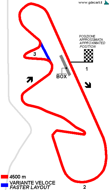
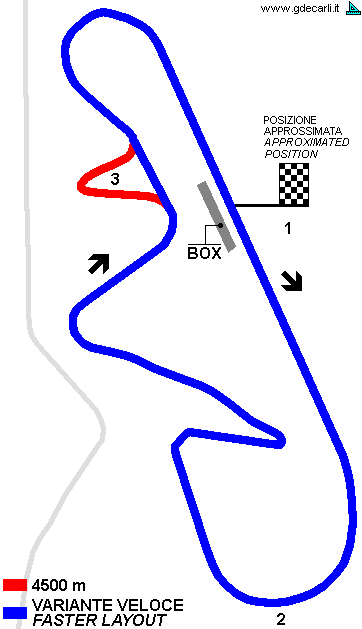
| Description | Permanent circuit designed by Sandro Rocci (who had already worked at Jarama), to be built in a mountainous area in Isle of Gran Canaria. Because of its climate, it would have been a perfect circuit to be used in winter, for tests and hypotetic races similar to Tasman Cup in Australia. The hill in point 1 (on the map) should have been excavated, so wonderful natural tribunes would have been created. First section of the main straight would have been flat, then in the last section it would have been uphill up to mid of first bend (point 2 on the map), the highest point of the circuit. Then downhill up to point 3. The hairpin at point 3 would have been very slow, so possibly it would have been eliminated. Pits would have been along main stright, but opened in opposite direction and lower than the track. Inauguration was scheduled before end of 1969. | ||||
| Years | 1968 | ||||
| Direction |  Clockwise Clockwise | ||||
 Proposal Proposal |
 YES YES
| ||||
| Proposal not developed | YES | ||||
| Car Circuit | YES | ||||
| Motorbike circuit | |||||
| Type | Permanent | ||||
| Inauguration | |||||
| Closing | |||||
| Last update of this page | October 16th 2008 | ||||
| Info last update | May 1968 | ||||
| Designer | Rocci Sandro Rocci | ||||
| Distinctive points | |||||
| length | 4500 m | 14764 ft | 2.796 mi | Original proposal | (4) |
| Maspalomas | |||||
| Description | I don’t know anything about the history of this track, nor the link with 1968 proposal. | ||||
| Years | |||||
| Direction |  Clockwise Clockwise | ||||
 Proposal Proposal |
NO | ||||
| No longer operational | |||||
| Car Circuit | YES | ||||
| Motorbike circuit | |||||
| Type | Permanent | ||||
| Inauguration | |||||
| Closing | |||||
| Last update of this page | October 16th 2008 | ||||
| Info last update | |||||
| Designer | |||||
| Distinctive points | |||||
| length | 4400 m | 14436 ft | 2.734 mi | Course A | (5) |
| length | 2200 m | 7218 ft | 1.367 mi | Course B | (5) |
| length | 2600 m | 8530 ft | 1.616 mi | Course C | (5) |
| length | 700 m | 2297 ft | 0.435 mi | Course D | (5) |
| length | 550 m | 1804 ft | 0.342 mi | Course E | (5) |
| length | 400 m | 1312 ft | 0.249 mi | Course F | (5) |
| length | 1600 m | 5249 ft | 0.994 mi | Course G | (5) |
| length | 1200 m | 3937 ft | 0.746 mi | Course I | (5) |
| length | 700 m | 2297 ft | 0.435 mi | Course J | (5) |
| length | 1300 m | 4265 ft | 0.808 mi | Course K | (5) |
| length | 1100 m | 3609 ft | 0.684 mi | Course K | (5) |
| Min width | 10 m | 33 ft | (5) | ||
| Max width | 24 m | 79 ft | Longest straight | (5) | |
Maspalomas: 1968 proposal, 4500 m original layout


| Updates | |||||||
| Date | Track layout | Years | Description by | Map by | Thanks to | Note | |
| October 16th 2008 | Guido de Carli | Roelard Smit | Update | Description | |||
| October 16th 2008 | Guido de Carli | Update | Description | ||||
| April 15th 2006 | 1968 | Guido de Carli | Guido de Carli | New | Description with map | ||
| Not all eventual updates issued in last years are already visible in this list | |||||||
