| USA - UNITED STATES | |||||||||||||||||||||
| SAN JOSÉ (HP PAVILION) | |||||||||||||||||||||
| Not to be confused with | San José (County Fairgrounds) - San José (McEnery) | ||||||||||||||||||||
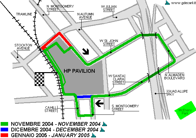
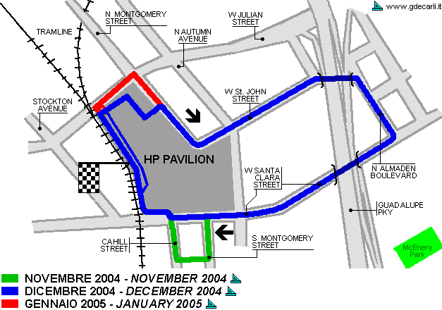
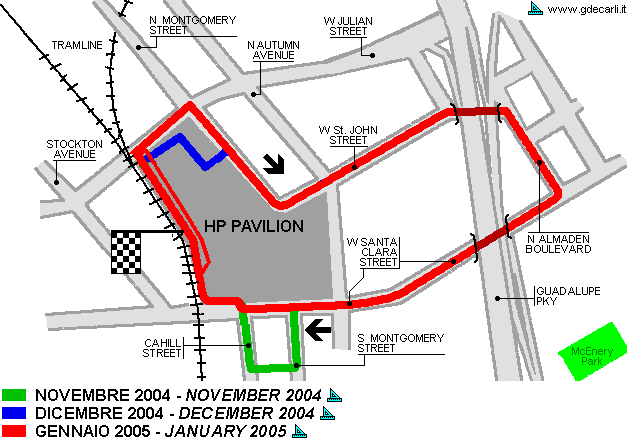
| Description | Proposed street circuit (there were at least 3 proposals quite similar between November 2004 and January 2005). It should have been in the parking and on the streets around HP Pavilion (a stadium). Main straight should have been in the parking, parallel to an existing tramline. Chicane at the end of W Santa Clara Street, before the last corner (only in first and second proposals; in the last one it was a 90° left corner), was just the entry in the parking. Likewise, the link between S Montgomery Street and Cahill Street (present in November proposal only) should have been on an exixting parking. It should have hosted ChampCar race scheduled on June 31st 2005. Because of high cost of realization, a couple of months before the race the organizators decided to move the race few blocks far and they create in a hurry the McEnery Center circuit. | ||||||||||||||||||||
| Location | San José CA - California - Western States | ||||||||||||||||||||
| Location | |||||||||||||||||||||
| Latitude - Longitude | + 37°20'01" -121°54'14" 37.333611 -121.903889 | ||||||||||||||||||||
| UTM Coordinates | X = 597101.486 - Y = 4132445.289 - Zone 10S | ||||||||||||||||||||
| Aerial photo / Map (*) |  OpenStreetMap - OpenStreetMap -  Google Maps - Google Maps -  Bing Maps - Bing Maps -  Flash Earth - Flash Earth -  Wikimapia - Wikimapia -  Microsoft Research Maps - Microsoft Research Maps -  MapQuest MapQuest | ||||||||||||||||||||
| Altitude AMSL | 28 m - 92 ft | ||||||||||||||||||||
| Inauguration | |||||||||||||||||||||
| Closing | |||||||||||||||||||||
| Designer | |||||||||||||||||||||
| Sources and links (Translation) (**) |
| ||||||||||||||||||||
| HP Pavilion | |||||
| Description | |||||
| Years | ? | ||||
| Direction |  Clockwise Clockwise | ||||
 Proposal Proposal |
 YES YES
| ||||
| Proposal not developed | YES | ||||
| Car Circuit | YES | ||||
| Motorbike circuit | |||||
| Type | Street course | ||||
| Inauguration | |||||
| Closing | |||||
| Last update of this page | December 18th 2007 | ||||
| Info last update | |||||
| Designer | |||||
| Distinctive points | |||||
| length | 3219 m | 10560 ft | 2 mi | (2) | |
| HP Pavilion | |||||
| Description | |||||
| Years | 2004 (11) | ||||
| Direction |  Clockwise Clockwise | ||||
 Proposal Proposal |
 YES YES
| ||||
| Proposal not developed | YES | ||||
| Car Circuit | YES | ||||
| Motorbike circuit | |||||
| Type | Street course | ||||
| Inauguration | |||||
| Closing | |||||
| Last update of this page | December 18th 2007 | ||||
| Info last update | November 2004 | ||||
| Designer | |||||
| Distinctive points | N Montgomery Street - W St. John Street - N Almaden Boulevard - W Santa Clara Street - S Montgomery Street - Cahill Street | ||||
| length | 3058 m | 10032 ft | 1.9 mi | (1) | |
| HP Pavilion | |||||
| Description | |||||
| Years | 2004 (12) | ||||
| Direction |  Clockwise Clockwise | ||||
 Proposal Proposal |
 YES YES
| ||||
| Proposal not developed | YES | ||||
| Car Circuit | YES | ||||
| Motorbike circuit | |||||
| Type | Street course | ||||
| Inauguration | |||||
| Closing | |||||
| Last update of this page | December 18th 2007 | ||||
| Info last update | December 2004 | ||||
| Designer | |||||
| Distinctive points | N Montgomery Street - W St. John Street - N Almaden Boulevard - W Santa Clara Street | ||||
| length | 2414 m | 7920 ft | 1.5 mi | (1) | |
| HP Pavilion | |||||
| Description | |||||
| Years | 2005 (01) | ||||
| Direction |  Clockwise Clockwise | ||||
 Proposal Proposal |
 YES YES
| ||||
| Proposal not developed | YES | ||||
| Car Circuit | YES | ||||
| Motorbike circuit | |||||
| Type | Street course | ||||
| Inauguration | |||||
| Closing | |||||
| Last update of this page | December 18th 2007 | ||||
| Info last update | January 2005 | ||||
| Designer | |||||
| Distinctive points | W Julian Street - N Montgomery Street - W St. John Street - N Almaden Boulevard - W Santa Clara Street | ||||
| length | 2253 m | 7392 ft | 1.4 mi | (1) | |
San José HP Pavilion: proposal November 2004

San José HP Pavilion: proposal December 2004

San José HP Pavilion: proposal January 2005

| Updates | |||||||
| Date | Track layout | Years | Description by | Map by | Thanks to | Note | |
| June 18th 2007 | Guido de Carli | Update | Description | ||||
| December 22nd 2005 | Guido de Carli | Lorenzo Tommasi | Update | Description | |||
| December 12th 2005 | Guido de Carli | Lorenzo Tommasi | Update | Description | |||
| December 3rd 2005 | Guido de Carli | Guido de Carli | Lorenzo Tommasi | Update | Description with map | ||
| November 18th 2005 | Guido de Carli | Lorenzo Tommasi | Update | Description | |||
| November 12th 2005 | Guido de Carli | Guido de Carli | Lorenzo Tommasi | New | Description with map | ||
| Not all eventual updates issued in last years are already visible in this list | |||||||
