| GRE - GREECE | |||||
| TRIPOLIS / ΤΡΊΠΟΛΗ | |||||
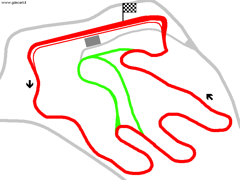
| Description | Project dated autumn 1993; completely different from what it has later built. It should have also an Indycar oval and a rally track. Scheduled Inauguration: Spring 1995 | ||||
| Location | Tripoli - Arcadia - Peloponneso / Peloponnese | ||||
| Location | |||||
| Latitude - Longitude (approx) | + 37°30'36" + 22°22'20" (approx) 37.51 22.372222 (approx) | ||||
| UTM Coordinates (approx) | X = 621277.654 - Y = 4152335.163 - Zone 34S (approx) | ||||
| Aerial photo / Map (*) |  OpenStreetMap - Google Maps - Bing Maps - Flash Earth - Wikimapia OpenStreetMap - Google Maps - Bing Maps - Flash Earth - Wikimapia | ||||
| Altitude AMSL (approx) | 650 m - 2133 ft (approx) | ||||
| Inauguration | |||||
| Closing | |||||
| Designer | |||||
| Sources and links (Translation) (**) |
| ||||
| Tripolis / Τρίπολη | |||||
| Description | |||||
| Years | |||||
| Direction |  Anticlockwise Anticlockwise | ||||
 Proposal Proposal |
YES
| ||||
| Proposal not developed | YES | ||||
| Car Circuit | YES | ||||
| Motorbike circuit | |||||
| Type | Permanent | ||||
| Inauguration | |||||
| Closing | |||||
| Last update of this page | April 30th 2006 | ||||
| Info last update | September 1993 | ||||
| Designer | |||||
| Distinctive points | |||||
| length | 6800 m | 22310 ft | 4.225 mi | (1) | |
Tripolis
| Updates | |||||||
| Date | Track layout | Years | Description by | Map by | Thanks to | Note | |
| April 15th 2004 | Guido de Carli | Guido de Carli | Update | Map | |||
| Not all eventual updates issued in last years are already visible in this list | |||||||


