| FIN - FINLAND | |||||||||||||||||||||||||
| ELÄINTARHARATA / DJURGÅRDSBANAN | |||||||||||||||||||||||||
| Description | Street track used from 1932 to 1963, then raced were canceled because they were too dangerous. | ||||||||||||||||||||||||
| Location | Helsinki / Helsingfors - Uusimaa / Nyland - Etelä-Suomen lääni / Södra Finlands län | ||||||||||||||||||||||||
| Location | Eläintarha - Djurgården, a park in downtown Helsinki, near Olimpic Stadium | ||||||||||||||||||||||||
| Latitude - Longitude | + 60°11'19" + 24°55'54" 60.188611 24.931667 | ||||||||||||||||||||||||
| UTM Coordinates | X = 385303.087 - Y = 6674213.236 - Zone 35V | ||||||||||||||||||||||||
| Aerial photo / Map (*) |  OpenStreetMap - Google Maps - Bing Maps - Flash Earth - Wikimapia - New Kosmosnimki - Eniro OpenStreetMap - Google Maps - Bing Maps - Flash Earth - Wikimapia - New Kosmosnimki - Eniro | ||||||||||||||||||||||||
| Altitude AMSL | 20 m - 66 ft | ||||||||||||||||||||||||
| Inauguration | 1932 | ||||||||||||||||||||||||
| Closing | May 19th 1963 | ||||||||||||||||||||||||
| Designer | |||||||||||||||||||||||||
| Sources and links (Translation) (**) |
| ||||||||||||||||||||||||
| Eläintarharata / Djurgårdsbanan | |||||
| Description | |||||
| Years | 1932 | ||||
| Direction |  Clockwise Clockwise | ||||
 Proposal Proposal |
NO | ||||
| No longer operational | YES | ||||
| Car Circuit | YES | ||||
| Motorbike circuit | |||||
| Type | Street course | ||||
| Inauguration | 1932 | ||||
| Closing | 1932 | ||||
| Last update of this page | May 10th 2005 | ||||
| Info last update | |||||
| Designer | |||||
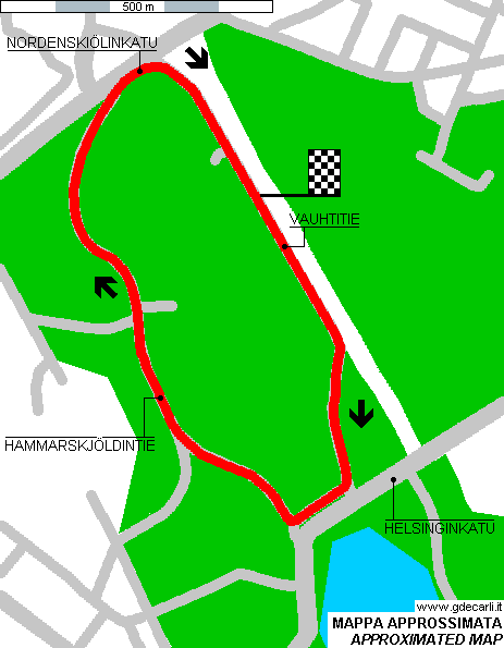
| Distinctive points | Vauhtitie - Helsinginkatu - Hammarskjöldintie - Nordenskiölinkatu | ||||
| Eläintarharata / Djurgårdsbanan | |||||
| Description | |||||
| Years | 1933÷1963 | ||||
| Direction | Clockwise | ||||
| Proposal |
NO | ||||
| No longer operational | YES | ||||
| Car Circuit | YES | ||||
| Motorbike circuit | |||||
| Type | Street course | ||||
| Inauguration | 1933 | ||||
| Closing | May 19th 1963 | ||||
| Last update of this page | May 10th 2005 | ||||
| Info last update | |||||
| Designer | |||||
| Distinctive points | Vauhtitie - Helsinginkatu - Hammarskjöldintie - Nordenskiölinkatu | ||||
| length | 2000 m | 6562 ft | 1.243 mi | (2) | |
| length | 2042 m | 6699 ft | 1.269 mi | Calculated from aerial photo (*) | (3) |
1933÷1963
See this track layout with milermeter.com
(milermeter.com can be used in your browser, without installing anything; Google Earth is a program that must be installed in your computer)
| Updates | |||||||
| Date | Track layout | Years | Description by | Map by | Thanks to | Note | |
| February 6th 2008 | 1933÷1963 | Lorenzo Tommasi | Update | Map | |||
| December 10th 2005 | Guido de Carli | Update | Description | ||||
| September 17th 2004 | Guido de Carli | Update | Description | ||||
| March 12th 2004 | 1933÷1963 | Guido de Carli | Guido de Carli | Update | Map | ||
| November 9th 2002 | 1933÷1963 | Guido de Carli | Guido de Carli | New | Map | ||
| August 13th 2002 | Guido de Carli | Update | Description | ||||
| Not all eventual updates issued in last years are already visible in this list | |||||||


