|
FIN - FINLAND |
| HÄMEENLINNA - AHVENISTO |
| SORRY, SOME DATA ARE NOT TRANSLATED YET |
| Description |
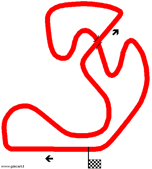
Second permanent Finnish circuit, after Keimola. It is in an undulating site and it has steep gradient and so it’s an interesting track. Its construction started in 1967, done by local Autoclub. In 1970 an extension was proposed, 1000 - 1500 m (0,62 - 0,93 mi) longer than the existing track: it should have had two tunnels. I think this proposal was not developed because of debts. I don’t know what eventual changes were made in its history; my map shows 1988 layout. |
| Location |
Hämeenlinna - Kanta-Häme / Egentliga Tavastland - Etelä-Suomen lääni / Södra Finlands län |
| Location |
|
| Latitude - Longitude |
+ 61°00'10" + 24°24'58"
61.002778 24.416111 |
| UTM Coordinates |
X = 360285.508 - Y = 6765852.922 - Zone 35V |
| Aerial photo / Map (*) |
 OpenStreetMap - OpenStreetMap -  Google Maps - Google Maps -  Bing Maps - Bing Maps -  Flash Earth - Flash Earth -  Wikimapia - Wikimapia -  New Kosmosnimki - New Kosmosnimki -  Eniro Eniro |
| Altitude AMSL |
104 m - 341 ft |
| Inauguration |
July 15th 1967 |
| Closing |
|
| Designer |
|
| Sources and links (Translation) (**) |
| (1) |
 |
Forum | Forum  Europe Europe  Northern Europe Northern Europe  FIN - Ahvenisto Circuit, Hämeenlinna [ENG] FIN - Ahvenisto Circuit, Hämeenlinna [ENG] | | (2) |
 |
ahvenistonfanisivut.com | | | (3) |
 |
ahvenistonfanisivut.com/ahvenisto_tulevaisuus.html | Map and description of 2011 proposed extension | | (4) |
 |
ahvenistonfanisivut.com/profiili.html | | | (5) |
 |
personal.inet.fi/urheilu/ahvenisto/index.html | | | (6) |
 |
www.racefoto.se/Racetrackssidan/Tracks.html | Tracks in Scandinavia by Racefoto Bengt-Åce Liljevind | | (7) |
 |
www.the-fastlane.co.uk/formula2/F368_E36.htm | F2 Register: aerial photo, map and result of the Formula 3 race dated June 7th 1968 | | (8) |
 |
Autosprint 21/1969 (page 19) | Mappa e dati essenziali | | (9) |
 |
Autosprint 35/1970 (page 17) | Descrizione | | (10) |
 |
Autosprint 26/1988 (page 71) | | | (11) |
 |
Rombo 26/1988 (page 54) | |
|
 OpenStreetMap -
  Google Maps -
  Bing Maps -
  Flash Earth -
  Wikimapia -
  New Kosmosnimki -
  Eniro
Eniro Clockwise
 Proposal
 Clockwise
 Proposal
 Clockwise
 Proposal
