| FRA - FRANCE | |||||||||||||||||||||||||||||||||||||||||||||
| LA CHÂTRE | |||||||||||||||||||||||||||||||||||||||||||||
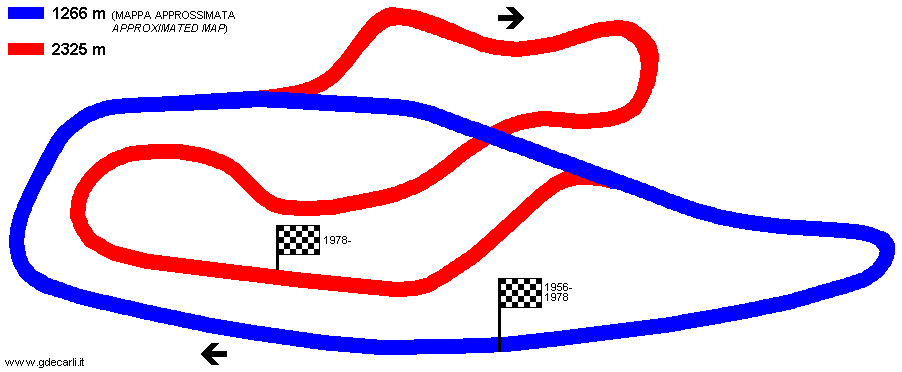
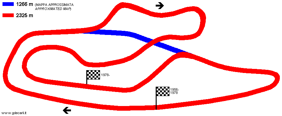
| Description | Since 1928 there are car races on Côte d’Ars track, on D943 Châtre-Châteauroux road. Few km far away, on June 17th 1956 new circuit was open, in 1266 m layout. Note that start/finish straight was on D940 La Châtre-Chavy road and there are no pits. In 1978 circuit was lengthened up to 2325 m, a new Circuit École (school circuit) 1100 m long was built (non shown on the map) and finally pits were built. Since 1995 only school circuit is operational. | ||||||||||||||||||||||||||||||||||||||||||||
| Location | La Châtre 36 - Indre - Centre | ||||||||||||||||||||||||||||||||||||||||||||
| Location | |||||||||||||||||||||||||||||||||||||||||||||
| Latitude - Longitude | + 46°35'38" + 2°00'25" 46.593889 2.006944 | ||||||||||||||||||||||||||||||||||||||||||||
| UTM Coordinates | X = 423932.409 - Y = 5160515.013 - Zone 31T | ||||||||||||||||||||||||||||||||||||||||||||
| Aerial photo / Map (*) |  OpenStreetMap - Google Maps - Bing Maps - Flash Earth - Wikimapia - GéoPortail OpenStreetMap - Google Maps - Bing Maps - Flash Earth - Wikimapia - GéoPortail | ||||||||||||||||||||||||||||||||||||||||||||
| Altitude AMSL | 206 m - 676 ft | ||||||||||||||||||||||||||||||||||||||||||||
| Inauguration | June 17th 1956 | ||||||||||||||||||||||||||||||||||||||||||||
| Closing | |||||||||||||||||||||||||||||||||||||||||||||
| Designer | |||||||||||||||||||||||||||||||||||||||||||||
| Sources and links (Translation) (**) |
| ||||||||||||||||||||||||||||||||||||||||||||
| La Châtre | |||||
| Description | |||||
| Years | 1956÷1978 | ||||
| Direction |  Clockwise Clockwise | ||||
 Proposal Proposal |
NO | ||||
| No longer operational | YES | ||||
| Car Circuit | YES | ||||
| Motorbike circuit | |||||
| Type | Road course | ||||
| Inauguration | June 17th 1956 | ||||
| Closing | 1978 | ||||
| Last update of this page | November 14th 2008 | ||||
| Info last update | |||||
| Designer | |||||
| Distinctive points | |||||
| length | 1250 m | 4101 ft | 0.777 mi | (4) | |
| length | 1266 m | 4154 ft | 0.787 mi | (9) | |
| length | 1267 m | 4157 ft | 0.787 mi | (8) | |
| length | 1246 m | 4088 ft | 0.774 mi | Calculated from aerial photo (*) | (5) |
| La Châtre | |||||
| Description | |||||
| Years | 1978÷1995? | ||||
| Direction |  Anticlockwise Anticlockwise | ||||
| Proposal |
NO | ||||
| No longer operational | YES | ||||
| Car Circuit | YES | ||||
| Motorbike circuit | |||||
| Type | Permanent | ||||
| Inauguration | 1978 | ||||
| Closing | 1995 | ||||
| Last update of this page | November 14th 2008 | ||||
| Info last update | |||||
| Designer | |||||
| Distinctive points | |||||
| length | 2325 m | 7628 ft | 1.445 mi | (10) | |
| length | 2121 m | 6960 ft | 1.318 mi | Calculated from aerial photo (*) | (7) |
| Circuit École | |||||
School circuit | |||||
| Description | |||||
| Years | |||||
| Direction | Clockwise | ||||
| Proposal |
NO | ||||
| No longer operational | |||||
| Car Circuit | YES | ||||
| Motorbike circuit | YES | ||||
| Type | Permanent | ||||
| Inauguration | 1978 | ||||
| Closing | |||||
| Last update of this page | November 14th 2008 | ||||
| Info last update | |||||
| Designer | |||||
| Distinctive points | |||||
| length | 1100 m | 3609 ft | 0.684 mi | (2) | |
| length | 1034 m | 3394 ft | 0.643 mi | Calculated from aerial photo (*) | (6) |
La Châtre 1956÷1978 (1266 m)
See this track layout with milermeter.com
(milermeter.com can be used in your browser, without installing anything; Google Earth is a program that must be installed in your computer)
La Châtre 1978÷1995? (2325 m)
See this track layout with milermeter.com
(milermeter.com can be used in your browser, without installing anything; Google Earth is a program that must be installed in your computer)
La Châtre, Circuit École
See this track layout with milermeter.com
(milermeter.com can be used in your browser, without installing anything; Google Earth is a program that must be installed in your computer)
| Updates | |||||||
| Date | Track layout | Years | Description by | Map by | Thanks to | Note | |
| November 14th 2008 | Guido de Carli | Vasco | Vasco | Update | Map | ||
| May 9th 2007 | Guido de Carli | Update | Description | ||||
| October 22nd 2004 | Guido de Carli | Guido de Carli | Update | Description with map | |||
| February 27th 2004 | Guido de Carli | Guido de Carli | New | Description with map | |||
| August 19th 2002 | Guido de Carli | Update | Description | ||||
| Not all eventual updates issued in last years are already visible in this list | |||||||


