| NOR - NORWAY | |||||
| NÆRBØ | |||||
| Description | |||||
| Location | Nærbø - Rogaland - Vestlandet | ||||
| Location | |||||
| Latitude - Longitude | + 58°39'55" + 5°38'20" 58.665278 5.638889 | ||||
| UTM Coordinates | X = 305076.956 - Y = 6507667.093 - Zone 32V | ||||
| Aerial photo / Map (*) |  OpenStreetMap - Google Maps - Bing Maps - Flash Earth - Wikimapia - Eniro OpenStreetMap - Google Maps - Bing Maps - Flash Earth - Wikimapia - Eniro | ||||
| Altitude AMSL | 31 m - 102 ft | ||||
| Inauguration | |||||
| Closing | |||||
| Designer | |||||
| Sources and links (Translation) (**) |
| ||||
| Nærbø | |||||
| Description | |||||
| Years | |||||
| Direction | |||||
 Proposal Proposal |
NO | ||||
| No longer operational | YES | ||||
| Car Circuit | |||||
| Motorbike circuit | |||||
| Type | Road course | ||||
| Inauguration | |||||
| Closing | |||||
| Last update of this page | May 31st 2007 | ||||
| Info last update | |||||
| Designer | |||||
| Distinctive points | |||||
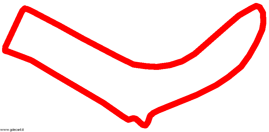
| length | 1200 m | 3937 ft | 0.746 mi | (1) | |
| Min width | 6 m | 20 ft | (1) | ||
| Max width | 11 m | 36 ft | (1) | ||
Nærbø
| Updates | |||||||
| Date | Track layout | Years | Description by | Map by | Thanks to | Note | |
| November 28th 2010 | Guido de Carli | Guido de Carli | Roelard Smit | Update | Description with map | ||
| May 31st 2007 | Guido de Carli | Update | Description | ||||
| Not all eventual updates issued in last years are already visible in this list | |||||||


