| FRA - FRANCE | |||||||||||||||||||||||||||||||||||||||||
| NICE | |||||||||||||||||||||||||||||||||||||||||
| Description | Sources don’t agree about years in which each layout was used, so I have no sure info (see detail) | ||||||||||||||||||||||||||||||||||||||||
| Location | Nice/Nizza 06 - Alpes-Maritimes - Provence-Alpes-Côte-d’Azur | ||||||||||||||||||||||||||||||||||||||||
| Location | |||||||||||||||||||||||||||||||||||||||||
| Latitude - Longitude | + 43°41'45" + 7°16'06" 43.695833 7.268333 | ||||||||||||||||||||||||||||||||||||||||
| UTM Coordinates | X = 360456.834 - Y = 4839547.585 - Zone 32T | ||||||||||||||||||||||||||||||||||||||||
| Aerial photo / Map (*) |  OpenStreetMap - Google Maps - Bing Maps - Flash Earth - Wikimapia - GéoPortail OpenStreetMap - Google Maps - Bing Maps - Flash Earth - Wikimapia - GéoPortail | ||||||||||||||||||||||||||||||||||||||||
| Altitude AMSL | 1 m - 3 ft | ||||||||||||||||||||||||||||||||||||||||
| Inauguration | 1932 | ||||||||||||||||||||||||||||||||||||||||
| Closing | 1947 | ||||||||||||||||||||||||||||||||||||||||
| Designer | |||||||||||||||||||||||||||||||||||||||||
| Sources and links (Translation) (**) |
| ||||||||||||||||||||||||||||||||||||||||
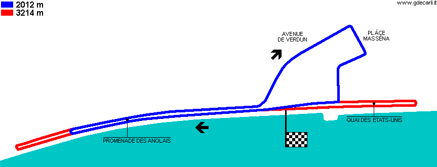
| Nice (2012 m) | |||||
| Description | According to Motor Racing Circuits Database (racingcircuits.net) this layout was used from 1932 to 1935. The GEL Motorsport - Tracks Around The World reports only that this one was used for the first time in 1932, without any more info. Other sources don’t report this track layout | ||||
| Years | |||||
| Direction |  Clockwise Clockwise | ||||
 Proposal Proposal |
NO | ||||
| No longer operational | YES | ||||
| Car Circuit | YES | ||||
| Motorbike circuit | |||||
| Type | Street course | ||||
| Inauguration | |||||
| Closing | |||||
| Last update of this page | November 25th 2007 | ||||
| Info last update | |||||
| Designer | |||||
| Distinctive points | Promenade des Anglais - Avenue de Verdun - Pláce Masséna | ||||
| length | 2012 m | 6600 ft | 1.25 mi | (6) | |
| length | 2012 m | 6600 ft | 1.25 mi | (7) | |
| length | 2130 m | 6987 ft | 1.323 mi | Calculated from aerial photo (*) | (4) |
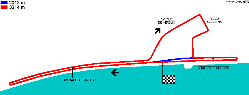
| Nice (3214 m) | |||||
| Description | According to Motor Racing Circuits Database (racingcircuits.net) this layout was used in 1946 and 1947. The GEL Motorsport - Tracks Around The World has the map, but without any more info. According to other sources, this track layout was in use even in 1930s | ||||
| Years | |||||
| Direction | Clockwise | ||||
| Proposal |
NO | ||||
| No longer operational | YES | ||||
| Car Circuit | YES | ||||
| Motorbike circuit | |||||
| Type | Street course | ||||
| Inauguration | |||||
| Closing | |||||
| Last update of this page | November 25th 2007 | ||||
| Info last update | |||||
| Designer | |||||
| Distinctive points | Promenade des Anglais - Avenue de Verdun - Pláce Masséna - Quai des Etats-Unis | ||||
| length | 3219 m | 10560 ft | 2 mi | (7) | |
| length | 3214 m | 10545 ft | 1.997 mi | (6) | |
| length | 3214 m | 10545 ft | 1.997 mi | (8) | |
| length | 2824 m | 9264 ft | 1.755 mi | Calculated from aerial photo (*) | (5) |
| Nice | |||||
| Description | Veteran car parade, held in 1984 and 1985 and probably alsoin following years. I have no info about track layout but the use of Promenade des Anglais | ||||
| Years | 1984÷... | ||||
| Direction | |||||
| Proposal |
NO | ||||
| No longer operational | |||||
| Car Circuit | YES | ||||
| Motorbike circuit | |||||
| Type | Historical parade | ||||
| Inauguration | 1984 | ||||
| Closing | |||||
| Last update of this page | February 10th 2008 | ||||
| Info last update | |||||
| Designer | |||||
| Distinctive points | Promenade des Anglais | ||||
Nice: comparison between short and long courses
Due to technical problems, temporarily it’s no longer possible to see the circuits on Google Maps embedded in the current page.
This feature will be restored as soon as I figure out how to do (any help would be appreciated!)
See this track layout with Google Earth
(milermeter.com can be used in your browser, without installing anything; Google Earth is a program that must be installed in your computer)
(Map shown here above can show at the same time all eventual layouts drawn. If you want to see only some of them, please go to Google Maps or Google Earth, by clicking on its own link)
Nice (2012 m)
Due to technical problems, temporarily it’s no longer possible to see the circuits on Google Maps embedded in the current page.
This feature will be restored as soon as I figure out how to do (any help would be appreciated!)
See this track layout with Google Earth
- milermeter.com
(milermeter.com can be used in your browser, without installing anything; Google Earth is a program that must be installed in your computer)
(Map shown here above can show at the same time all eventual layouts drawn. If you want to see only some of them, please go to Google Maps or Google Earth, by clicking on its own link)
Nice (3214 m)
Due to technical problems, temporarily it’s no longer possible to see the circuits on Google Maps embedded in the current page.
This feature will be restored as soon as I figure out how to do (any help would be appreciated!)
See this track layout with Google Earth
- milermeter.com
(milermeter.com can be used in your browser, without installing anything; Google Earth is a program that must be installed in your computer)
(Map shown here above can show at the same time all eventual layouts drawn. If you want to see only some of them, please go to Google Maps or Google Earth, by clicking on its own link)
| Updates | |||||||
| Date | Track layout | Years | Description by | Map by | Thanks to | Note | |
| December 27th 2010 | Guido de Carli | andylaurence | Update | Description | |||
| February 10th 2008 | 1984÷... | Guido de Carli | Update | Description | |||
| November 25th 2007 | Guido de Carli | Guido de Carli | Lorenzo Tommasi | Update | Description with map | ||
| December 23rd 2003 | Guido de Carli | New | Description | ||||
| Not all eventual updates issued in last years are already visible in this list | |||||||


