| FRA - FRANCE | |||||||||||||||||||||||||||||||||||||||||||||||||
| PAU | |||||||||||||||||||||||||||||||||||||||||||||||||
| SORRY, SOME DATA ARE NOT TRANSLATED YET | |||||||||||||||||||||||||||||||||||||||||||||||||
| Not to be confused with | Pau (1930) - Pau, Sud-Ouest - Pau-Arnos | ||||||||||||||||||||||||||||||||||||||||||||||||
| Description | |||||||||||||||||||||||||||||||||||||||||||||||||
| Location | Pau 64 - Pyrénées-Atlantiques - Aquitaine | ||||||||||||||||||||||||||||||||||||||||||||||||
| Location | |||||||||||||||||||||||||||||||||||||||||||||||||
| Latitude - Longitude | + 43°17'31" - 0°21'57" 43.291944 -0.365833 | ||||||||||||||||||||||||||||||||||||||||||||||||
| UTM Coordinates | X = 713691.897 - Y = 4796605.136 - Zone 30T | ||||||||||||||||||||||||||||||||||||||||||||||||
| Aerial photo / Map (*) |  OpenStreetMap - Google Maps - Bing Maps - Flash Earth - Wikimapia - GéoPortail OpenStreetMap - Google Maps - Bing Maps - Flash Earth - Wikimapia - GéoPortail | ||||||||||||||||||||||||||||||||||||||||||||||||
| Altitude AMSL | 178 m - 584 ft | ||||||||||||||||||||||||||||||||||||||||||||||||
| Inauguration | 1933 | ||||||||||||||||||||||||||||||||||||||||||||||||
| Closing | |||||||||||||||||||||||||||||||||||||||||||||||||
| Designer | |||||||||||||||||||||||||||||||||||||||||||||||||
| Sources and links (Translation) (**) |
| ||||||||||||||||||||||||||||||||||||||||||||||||
| Pau | |||||
| Description | |||||
| Years | 1933 | ||||
| Direction |  Clockwise Clockwise | ||||
 Proposal Proposal |
NO | ||||
| No longer operational | YES | ||||
| Car Circuit | YES | ||||
| Motorbike circuit | |||||
| Type | Street course | ||||
| Inauguration | 1933 | ||||
| Closing | 1933 | ||||
| Last update of this page | May 8th 2007 | ||||
| Info last update | |||||
| Designer | |||||
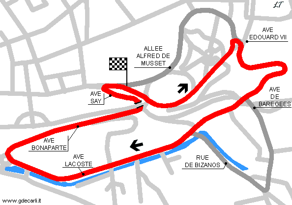
| Distinctive points | Casino - Epingle des Réparatrices - Avenue du Général Poeymiraud - Virage du Buisson - Chicane - Avenue du Bois Louis - Virage de la Gare - Avenue Léon Say - Pont Oscar - Virage du Lycée | ||||
| length | 2649 m | 8691 ft | 1.646 mi | (7) | |
| Pau | |||||
| Description | |||||
| Years | 1935÷... | ||||
| Direction | Clockwise | ||||
| Proposal |
NO | ||||
| No longer operational | YES | ||||
| Car Circuit | YES | ||||
| Motorbike circuit | |||||
| Type | Street course | ||||
| Inauguration | February 24th 1935 | ||||
| Closing | |||||
| Last update of this page | May 8th 2007 | ||||
| Info last update | |||||
| Designer | |||||
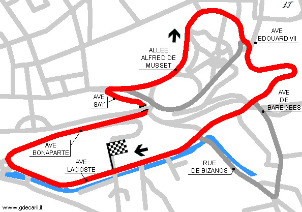
| Distinctive points | Avenue Gaston Lacoste - Virage de la Gare - Avenue Léon Say - Pont Oscar - Virage du Lycée - Casino - Parc Beaumont - Virage Foch - Avenue du Général Poeymiraud - Virage du Buisson - Chicane | ||||
| length | 2760 m | 9055 ft | 1.715 mi | (6) | |
| length | 2760 m | 9055 ft | 1.715 mi | (5) | |
| length | 2770 m | 9088 ft | 1.721 mi | (8) | |
| Pau | |||||
| Description | In October 2002 an extension of the track was proposed, in order to host important categories such as Champ Car, FIA GT world championship, DTM, F.3000 or international F.3. | ||||
| Years | |||||
| Direction | Clockwise | ||||
| Proposal |
YES
| ||||
| Proposal not developed | |||||
| Car Circuit | YES | ||||
| Motorbike circuit | |||||
| Type | Street course | ||||
| Inauguration | |||||
| Closing | |||||
| Last update of this page | May 17th 2009 | ||||
| Info last update | |||||
| Designer | |||||
| Distinctive points | Avenue Gaston Lacoste - Virage de la Gare - Avenue Léon Say - Pont Oscar - Virage du Lycée - Casino - Parc Beaumont - Virage Foch - Avenue du Général Poeymiraud - Virage du Buisson - Avenue de Barèges - Rue Georges Clemenceau - Rue de Bizanos | ||||
| length | 3235 m | 10614 ft | 2.01 mi | (6) | |
| length | 3236 m | 10617 ft | 2.011 mi | (5) | |
Pau 1933
Pau 1935÷...
Pau - 2003÷2004 proposed extension

Pau - 2003÷2004 proposed extension
Due to technical problems, temporarily it’s no longer possible to see the circuits on Google Maps embedded in the current page.
This feature will be restored as soon as I figure out how to do (any help would be appreciated!)
See this track layout with Google Earth
(milermeter.com can be used in your browser, without installing anything; Google Earth is a program that must be installed in your computer)
(Map shown here above can show at the same time all eventual layouts drawn. If you want to see only some of them, please go to Google Maps or Google Earth, by clicking on its own link)
| Updates | |||||||
| Date | Track layout | Years | Description by | Map by | Thanks to | Note | |
| May 19th 2009 | Guido de Carli | Update | Description | ||||
| May 17th 2009 | Guido de Carli | Roelard Smit | Update | Description | |||
| May 8th 2007 | Guido de Carli | Lorenzo Tommasi | Update | Map | |||
| May 7th 2007 | Lorenzo Tommasi | Update | Photos (link) | ||||
| April 25th 2004 | Guido de Carli | New | Description | ||||
| Not all eventual updates issued in last years are already visible in this list | |||||||


