| LAT - LATVIA | |||||||||
| MEZA PARK | |||||||||
| Description | Track used in 1964÷1965 and maybe even in 1966 | ||||||||
| Location | Riga / Rīga - Rīga | ||||||||
| Location | North of Riga Town Center | ||||||||
| Latitude - Longitude | + 57°01'01" + 24°09'15" 57.016944 24.154167 | ||||||||
| UTM Coordinates | X = 327229.185 - Y = 6322872.399 - Zone 35V | ||||||||
| Aerial photo / Map (*) |  OpenStreetMap - Google Maps - Bing Maps - Flash Earth - Wikimapia - New Kosmosnimki OpenStreetMap - Google Maps - Bing Maps - Flash Earth - Wikimapia - New Kosmosnimki | ||||||||
| Altitude AMSL | 20 m - 66 ft | ||||||||
| Inauguration | 1964 | ||||||||
| Closing | |||||||||
| Designer | |||||||||
| Sources and links (Translation) (**) |
| ||||||||
| Meza Park | |||||
| Description | |||||
| Years | 1964÷1966? | ||||
| Direction | |||||
 Proposal Proposal |
NO | ||||
| No longer operational | YES | ||||
| Car Circuit | YES | ||||
| Motorbike circuit | |||||
| Type | Street course | ||||
| Inauguration | 1964 | ||||
| Closing | |||||
| Last update of this page | November 11th 2007 | ||||
| Info last update | |||||
| Designer | |||||
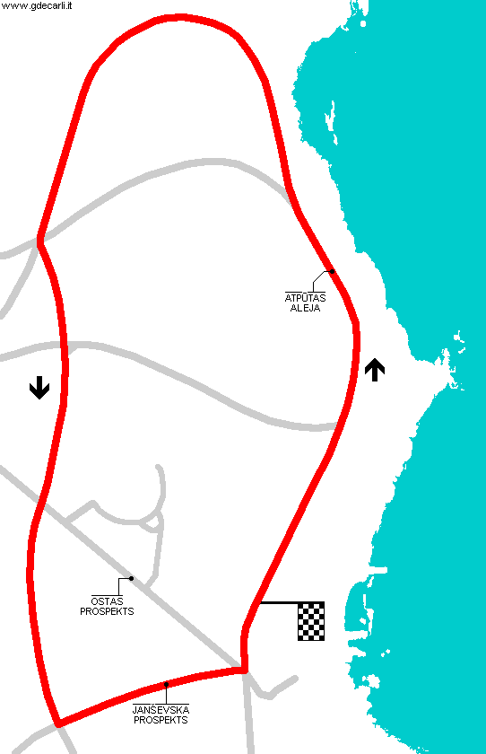
| Distinctive points | Aptūtas Aleja - Janševska Prospekts | ||||
| length (approx) | 3500 m | 11483 ft | 2.175 mi | Calculated from aerial photo (*) | (1) |
Meza Park
Due to technical problems, temporarily it’s no longer possible to see the circuits on Google Maps embedded in the current page.
This feature will be restored as soon as I figure out how to do (any help would be appreciated!)
See this track layout with Google Earth
- milermeter.com
(milermeter.com can be used in your browser, without installing anything; Google Earth is a program that must be installed in your computer)
(Map shown here above can show at the same time all eventual layouts drawn. If you want to see only some of them, please go to Google Maps or Google Earth, by clicking on its own link)
| Updates | |||||||
| Date | Track layout | Years | Description by | Map by | Thanks to | Note | |
| November 11th 2007 | Lorenzo Tommasi | Guido de Carli | New | Description with map | |||
| October 19th 2004 | Guido de Carli | New | Description | ||||
| Not all eventual updates issued in last years are already visible in this list | |||||||


