| GER - GERMANY | |||||||||
| BAYERNRING (LAUTERHOFEN) | |||||||||
| Not to be confused with | Bayernring (Erbendorf) - Bayernring (Mantel) - Bayernring (Weiden) | ||||||||
| Description | Abandoned proposal for a great permament circuit. | ||||||||
| Location | Lauterhofen BY - Bayern - 1949÷1990: BRD | ||||||||
| Location | |||||||||
| Latitude - Longitude (approx) | + 49°22'09" + 11°36'17" (approx) 49.369167 11.604722 (approx) | ||||||||
| UTM Coordinates (approx) | X = 689094.1 - Y = 5471758.682 - Zone 32U (approx) | ||||||||
| Aerial photo / Map (*) |  OpenStreetMap - Google Maps - Bing Maps - Flash Earth - Wikimapia - GoYellow.de OpenStreetMap - Google Maps - Bing Maps - Flash Earth - Wikimapia - GoYellow.de | ||||||||
| Altitude AMSL (approx) | 480 m - 1575 ft (approx) | ||||||||
| Inauguration | |||||||||
| Closing | |||||||||
| Designer | |||||||||
| Sources and links (Translation) (**) |
| ||||||||
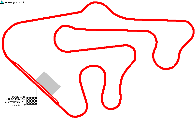
| Bayernring (Lauterhofen) | |||||
| Description | |||||
| Years | 1978? | ||||
| Direction | |||||
 Proposal Proposal |
YES
| ||||
| Proposal not developed | YES | ||||
| Car Circuit | YES | ||||
| Motorbike circuit | |||||
| Type | Permanent | ||||
| Inauguration | |||||
| Closing | |||||
| Last update of this page | September 4th 2008 | ||||
| Info last update | |||||
| Designer | |||||
| Distinctive points | |||||
Bayernring (Lauterhofen)
| Updates | |||||||
| Date | Track layout | Years | Description by | Map by | Thanks to | Note | |
| September 4th 2008 | 1978? | Guido de Carli | Guido de Carli | Lorenzo Tommasi | New | Description with map | |
| Not all eventual updates issued in last years are already visible in this list | |||||||


