| MAR - MOROCCO | |||||||||
| KÉNITRA | |||||||||
| Description | Circuit first used in 1970. I don’t know if it was used for some more times later. | ||||||||
| Location | Kénitra - Kénitra - Gharb-Chrarda-Béni Hssen | ||||||||
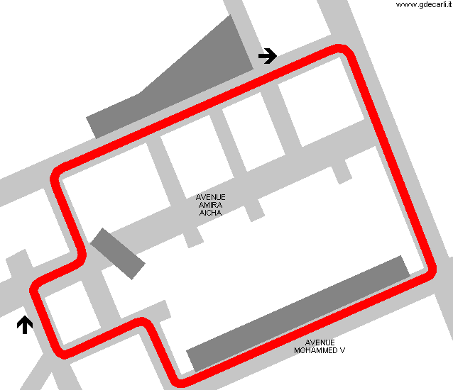
| Location | Around Avenue Amira Aicha | ||||||||
| Latitude - Longitude (approx) | + 34°15'42" - 6°34'56" (approx) 34.261667 -6.582222 (approx) | ||||||||
| UTM Coordinates (approx) | X = 722613.992 - Y = 3793814.911 - Zone 29S (approx) | ||||||||
| Aerial photo / Map (*) |  OpenStreetMap - Google Maps - Bing Maps - Flash Earth - Wikimapia OpenStreetMap - Google Maps - Bing Maps - Flash Earth - Wikimapia | ||||||||
| Altitude AMSL (approx) | 13 m - 43 ft (approx) | ||||||||
| Inauguration | October 18th 1970 | ||||||||
| Closing | |||||||||
| Designer | |||||||||
| Sources and links (Translation) (**) |
| ||||||||
| Kénitra | |||||
| Description | |||||
| Years | 1970 | ||||
| Direction |  Anticlockwise Anticlockwise | ||||
 Proposal Proposal |
NO | ||||
| No longer operational | YES | ||||
| Car Circuit | YES | ||||
| Motorbike circuit | |||||
| Type | Street course | ||||
| Inauguration | October 18th 1970 | ||||
| Closing | |||||
| Last update of this page | February 21st 2009 | ||||
| Info last update | |||||
| Designer | |||||
| Distinctive points | |||||
| length | 1200 m | 3937 ft | 0.746 mi | (1) | |
| length | 1225 m | 4019 ft | 0.761 mi | Calculated from aerial photo (*) | (2) |
Kénitra
See this track layout with milermeter.com
(milermeter.com can be used in your browser, without installing anything; Google Earth is a program that must be installed in your computer)
| Updates | |||||||
| Date | Track layout | Years | Description by | Map by | Thanks to | Note | |
| February 21st 2009 | 1970 | Guido de Carli | Guido de Carli | Update | Description with map | ||
| February 14th 2009 | 1970 | Guido de Carli | Guido de Carli | New | Description with map | ||
| Not all eventual updates issued in last years are already visible in this list | |||||||


