| SVK - SLOVAKIA | |||||||||
| KOPČANY | |||||||||
| Description | |||||||||
| Location | Kopčany - Trnavský kraj - Západné Slovensko | ||||||||
| Location | Up to 1992 it was in Czechoslovakia | ||||||||
| Latitude - Longitude | + 48°47'22" + 17°07'04" 48.789444 17.117778 | ||||||||
| UTM Coordinates | X = 655546.881 - Y = 5406212.763 - Zone 33U | ||||||||
| Aerial photo / Map (*) |  OpenStreetMap - Google Maps - Bing Maps - Flash Earth - Wikimapia - Mapy.cz - Mapy.sk OpenStreetMap - Google Maps - Bing Maps - Flash Earth - Wikimapia - Mapy.cz - Mapy.sk | ||||||||
| Altitude AMSL | 163 m - 535 ft | ||||||||
| Inauguration | 1967 | ||||||||
| Closing | 1993 | ||||||||
| Designer | |||||||||
| Sources and links (Translation) (**) |
| ||||||||
| Kopčany, Záhorácky okruh | |||||
| Description | |||||
| Years | |||||
| Direction | |||||
 Proposal Proposal |
NO | ||||
| No longer operational | YES | ||||
| Car Circuit | |||||
| Motorbike circuit | YES | ||||
| Type | Street course | ||||
| Inauguration | 1967 | ||||
| Closing | |||||
| Last update of this page | May 20th 2009 | ||||
| Info last update | |||||
| Designer | |||||
| Distinctive points | |||||
| length | 2186 m | 7172 ft | 1.358 mi | (1) | |
| Kopčany, Záhorácky okruh | |||||
| Description | |||||
| Years | |||||
| Direction | |||||
| Proposal |
NO | ||||
| No longer operational | YES | ||||
| Car Circuit | |||||
| Motorbike circuit | YES | ||||
| Type | Street course | ||||
| Inauguration | |||||
| Closing | |||||
| Last update of this page | May 20th 2009 | ||||
| Info last update | |||||
| Designer | |||||
| Distinctive points | |||||
| length | 2297 m | 7536 ft | 1.427 mi | (1) | |
| Kopčany, Záhorácky okruh | |||||
| Description | |||||
| Years | |||||
| Direction | |||||
| Proposal |
NO | ||||
| No longer operational | YES | ||||
| Car Circuit | |||||
| Motorbike circuit | YES | ||||
| Type | Street course | ||||
| Inauguration | |||||
| Closing | |||||
| Last update of this page | May 20th 2009 | ||||
| Info last update | |||||
| Designer | |||||
| Distinctive points | |||||
| length | 3570 m | 11713 ft | 2.218 mi | (1) | |
| Kopčany, Záhorácky okruh | |||||
| Description | Note: length found is very different from one calculated on aerial photos | ||||
| Years | |||||
| Direction |  Anticlockwise Anticlockwise | ||||
| Proposal |
NO | ||||
| No longer operational | YES | ||||
| Car Circuit | |||||
| Motorbike circuit | YES | ||||
| Type | Street course | ||||
| Inauguration | |||||
| Closing | 1993 | ||||
| Last update of this page | May 20th 2009 | ||||
| Info last update | |||||
| Designer | |||||
| Distinctive points | |||||
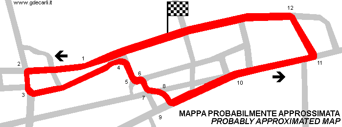
| length | 3700 m | 12139 ft | 2.299 mi | (1) | |
| length | 3215 m | 10548 ft | 1.998 mi | Calculated from aerial photo (*) | (2) |
| Min width | 7.2 m | 24 ft | (1) | ||
Kopcany, Záhorácky okruh
See this track layout with milermeter.com
(milermeter.com can be used in your browser, without installing anything; Google Earth is a program that must be installed in your computer)
| PHOTOS |
| Photos of long course (3700 m) published here with author’s authorization. Description in English are by the author, translation in Italian is mine. |
| Photos by David Griac (jpm) - |
| Click on thumbnail to open original large photo |
| 1 | 2 | 3 | 4 |
 |  |  |  |
| Starting line | moving on | negotiate church |
| 5 | 6 | 7 | 8 |
 |  |  |  |
| past catholics | Turn 1 | Turn 1 exit | out of Turn 1 |
| 9 | 10 | 11 | 12 |
 |  |  |  |
| into Turn 2 | Turn 2: lined | Turn 2 backwards | Turn 2 exit |
| 13 | 14 | 15 | 16 |
 |  |  |  |
| Turn 3 | Turn 3: curbs & lines | Turn 3 exit | out of Turn 3 |
| 17 | 18 | 19 | 20 |
 |  |  |  |
| back to church | into Turn 4 |
| 21 | 22 | 23 | 24 |
 |  |  |  |
| Turn 4: see the line bend | Turn 4 |
| 25 | 26 | 27 | 28 |
 |  |  |  |
| out of Turn 4 | Post Office section | Turn 5 |
| 29 | 30 | 31 | 32 |
 |  |  |  |
| Turn 6 | Turn 6 backwards | into Turn 7 |
| 33 | 34 | 35 | 36 |
 |  |  |  |
| Turn 7 | into Turn 8 | Turn 8 | Turn 8 details |
| 37 | 38 | 39 | 40 |
 |  |  |  |
| Turn 8 banking | Turn 8 backwards | Turn 9 | Turn 9 exit |
| 41 | 42 | 43 | 44 |
 |  |  |  |
| backstraight | backstraight on | into Turn 10 | Turn 10 exit (+Holic) |
| 45 | 46 | 47 | 48 |
 |  |  |  |
| nearing Turn 11 | into Turn 11 | Turn 11 |
| 49 | 50 | 51 | 52 |
 |  |  |  |
| Turn 11: race track line | past Turn 11 | Turn 12 |
| 53 | 54 | 55 | 56 |
 |  |  |  |
| Turn 12 exit | Turn 12 backwards |
| 57 | 58 | 59 | 60 |
 |  |  |  |
| out of Turn 12 | down to bridge | bridge |
| 61 | 62 | ||
 |  | ||
| uphill back to start | finishing |
| Updates | |||||||
| Date | Track layout | Years | Description by | Map by | Thanks to | Note | |
| May 20th 2009 | Guido de Carli | Guido de Carli | David Griac (jpm) | New | Description with map | ||
| May 20th 2009 | Guido de Carli | David Griac (jpm) | New | Photos (on this site) | |||
| Not all eventual updates issued in last years are already visible in this list | |||||||


