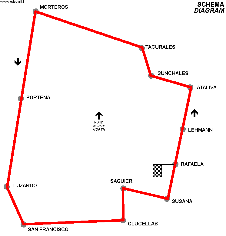
| ARG - ARGENTINA | |
| RAFAELA (1919) | |
| Not to be confused with | Rafaela (1920÷1924) - Rafaela (1925) - Rafaela (1926) - Rafaela (1927÷1928) - Rafaela (1929÷1930) - Rafaela (1935) - Rafaela (1936÷1941) - Rafaela (1947, Parque) - Rafaela (1947÷1951) - Rafaela, Autódromo / Báscolo |
| Description | Circuit used only once on May 25th 1919 for a Fuerza Libre race won by Oberdan Piovano (Overland) |
| Location | Rafaela S - Santa Fé - Centro |
| Location | |
| Latitude - Longitude (approx) | - 31°12'27" - 61°28'35" (approx) -31.2075 -61.476389 (approx) |
| UTM Coordinates (approx) | X = 645145.215 - Y = 6546401.406 - Zone 20J (approx) |
| Aerial photo / Map (*) |  OpenStreetMap - OpenStreetMap -  Google Maps - Google Maps -  Bing Maps - Bing Maps -  Flash Earth - Flash Earth -  Wikimapia Wikimapia |
| Altitude AMSL (approx) | 100 m - 328 ft (approx) |
| Inauguration | May 25th 1919 |
| Closing | May 25th 1919 |
| Designer | |
| Sources and links (Translation) (**) | |
| Rafaela (1919) | |||||
| Description | |||||
| Years | 1919 | ||||
| Direction |  Anticlockwise Anticlockwise | ||||
 Proposal Proposal |
NO | ||||
| No longer operational | YES | ||||
| Car Circuit | YES | ||||
| Motorbike circuit | |||||
| Type | Road course | ||||
| Inauguration | May 25th 1919 | ||||
| Closing | May 25th 1919 | ||||
| Last update of this page | June 7th 2010 | ||||
| Info last update | |||||
| Designer | |||||
| Distinctive points | Rafaela - Lehmann - Ataliva - Sunchales - Tacurales - Morteros - Porteña - Luzardo - San Francisco - Clucellas - Saguier - Susana - Rafaela | ||||
| length | 320 km | 198.844 mi | (3) | ||
| Average Speed | 77.108 km/h | 47.914 mph | Winner average speed | (3) | |
Rafaela (1919)

| Updates | |||||||
| Date | Track layout | Years | Description by | Map by | Thanks to | Note | |
| June 7th 2010 | 1919 | Guido de Carli | Guido de Carli | Luis Alberto González | New | Description with map | |
| Not all eventual updates issued in last years are already visible in this list | |||||||
