| JPN - JAPAN | |||||||||||||||||
| MT. NORO SPEED PARK | |||||||||||||||||
| Description | |||||||||||||||||
| Location | Kure - Hiroshima - Chūgoku | ||||||||||||||||
| Location | |||||||||||||||||
| Latitude - Longitude | + 34°16'09" +132°40'32" 34.269167 132.675556 | ||||||||||||||||
| UTM Coordinates | X = 286000.41 - Y = 3794446.415 - Zone 53S | ||||||||||||||||
| Aerial photo / Map (*) |  OpenStreetMap - Google Maps - Bing Maps - Flash Earth - Wikimapia - portal.cyberjapan.jp OpenStreetMap - Google Maps - Bing Maps - Flash Earth - Wikimapia - portal.cyberjapan.jp | ||||||||||||||||
| Altitude AMSL | 713 m - 2339 ft | ||||||||||||||||
| Inauguration | May 5th 1970 | ||||||||||||||||
| Closing | 1974 | ||||||||||||||||
| Designer | |||||||||||||||||
| Sources and links (Translation) (**) |
| ||||||||||||||||
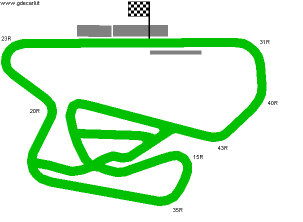
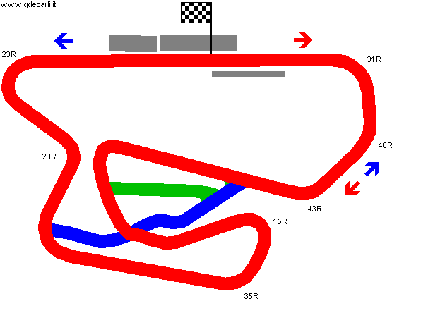
| Full course | |||||
Full circuit | |||||
| Description | |||||
| Years | 1970÷1974 | ||||
| Direction |  Clockwise Clockwise | ||||
 Proposal Proposal |
NO | ||||
| No longer operational | YES | ||||
| Car Circuit | YES | ||||
| Motorbike circuit | |||||
| Type | Permanent | ||||
| Inauguration | May 5th 1970 | ||||
| Closing | 1970 | ||||
| Last update of this page | October 23rd 2010 | ||||
| Info last update | |||||
| Designer | |||||
| Distinctive points | 31R - 40R - 43R - 35R - 20R - 23R | ||||
| length | 1300 m | 4265 ft | 0.808 mi | (1) | |
| length | 1309 m | 4296 ft | 0.814 mi | Calculated from aerial photo (*) | (3) |
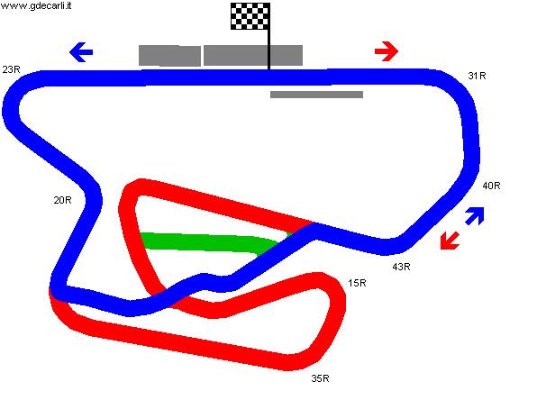
| Stock Car Course | |||||
| Description | |||||
| Years | 1970÷1974 | ||||
| Direction |  Anticlockwise Anticlockwise | ||||
| Proposal |
NO | ||||
| No longer operational | YES | ||||
| Car Circuit | YES | ||||
| Motorbike circuit | |||||
| Type | Permanent | ||||
| Inauguration | May 5th 1970 | ||||
| Closing | 1970 | ||||
| Last update of this page | October 23rd 2010 | ||||
| Info last update | |||||
| Designer | |||||
| Distinctive points | 23R - 20R - 43R - 40R - 31R | ||||
| length | 932 m | 3058 ft | 0.579 mi | (1) | |
| length | 898 m | 2946 ft | 0.558 mi | Calculated from aerial photo (*) | (2) |
Mt. Noro Speed Park: Full Course and Stock Course
Due to technical problems, temporarily it’s no longer possible to see the circuits on Google Maps embedded in the current page.
This feature will be restored as soon as I figure out how to do (any help would be appreciated!)
See this track layout with Google Earth
(milermeter.com can be used in your browser, without installing anything; Google Earth is a program that must be installed in your computer)
(Map shown here above can show at the same time all eventual layouts drawn. If you want to see only some of them, please go to Google Maps or Google Earth, by clicking on its own link)
Mt. Noro Speed Park: Full Course
Due to technical problems, temporarily it’s no longer possible to see the circuits on Google Maps embedded in the current page.
This feature will be restored as soon as I figure out how to do (any help would be appreciated!)
See this track layout with Google Earth
- milermeter.com
(milermeter.com can be used in your browser, without installing anything; Google Earth is a program that must be installed in your computer)
(Map shown here above can show at the same time all eventual layouts drawn. If you want to see only some of them, please go to Google Maps or Google Earth, by clicking on its own link)
Mt. Noro Speed Park: Stock Course
Due to technical problems, temporarily it’s no longer possible to see the circuits on Google Maps embedded in the current page.
This feature will be restored as soon as I figure out how to do (any help would be appreciated!)
See this track layout with Google Earth
- milermeter.com
(milermeter.com can be used in your browser, without installing anything; Google Earth is a program that must be installed in your computer)
(Map shown here above can show at the same time all eventual layouts drawn. If you want to see only some of them, please go to Google Maps or Google Earth, by clicking on its own link)
| Updates | |||||||
| Date | Track layout | Years | Description by | Map by | Thanks to | Note | |
| October 23rd 2010 | Guido de Carli | Avril | Avril | New | Description with map | ||
| Not all eventual updates issued in last years are already visible in this list | |||||||


