| ARG - ARGENTINA | |||||||||||||||||||||||||||||||||||||||||||||||||||||||||||||||||||||||||||||
| TANDIL, SERRANO, VUELTA DE LA CARRETTERA (1952÷1966) | |||||||||||||||||||||||||||||||||||||||||||||||||||||||||||||||||||||||||||||
| Not to be confused with | Tandil, Hipódromo - Tandil, Mixto (1967) - Tandil, Panoramico (1977÷1992) - Tandil, Rutero (1950÷1951) | ||||||||||||||||||||||||||||||||||||||||||||||||||||||||||||||||||||||||||||
| Description | |||||||||||||||||||||||||||||||||||||||||||||||||||||||||||||||||||||||||||||
| Location | Tandil B - Buenos Aires - Buenos Aires | ||||||||||||||||||||||||||||||||||||||||||||||||||||||||||||||||||||||||||||
| Location | |||||||||||||||||||||||||||||||||||||||||||||||||||||||||||||||||||||||||||||
| Latitude - Longitude | - 37°21'51" - 59°07'49" -37.364167 -59.130278 | ||||||||||||||||||||||||||||||||||||||||||||||||||||||||||||||||||||||||||||
| UTM Coordinates | X = 311352.457 - Y = 5862599.277 - Zone 21H | ||||||||||||||||||||||||||||||||||||||||||||||||||||||||||||||||||||||||||||
| Aerial photo / Map (*) |  OpenStreetMap - Google Maps - Bing Maps - Flash Earth - Wikimapia OpenStreetMap - Google Maps - Bing Maps - Flash Earth - Wikimapia | ||||||||||||||||||||||||||||||||||||||||||||||||||||||||||||||||||||||||||||
| Altitude AMSL | 190 m - 623 ft | ||||||||||||||||||||||||||||||||||||||||||||||||||||||||||||||||||||||||||||
| Inauguration | December 7th 1952 | ||||||||||||||||||||||||||||||||||||||||||||||||||||||||||||||||||||||||||||
| Closing | November 13th 1966 | ||||||||||||||||||||||||||||||||||||||||||||||||||||||||||||||||||||||||||||
| Designer | |||||||||||||||||||||||||||||||||||||||||||||||||||||||||||||||||||||||||||||
| Sources and links (Translation) (**) |
| ||||||||||||||||||||||||||||||||||||||||||||||||||||||||||||||||||||||||||||
| Circuito Serrano, Vuelta de la Carrettera | |||||
| Description | Track reconstruction I made could be a little approximated, moreover in Tandil | ||||
| Years | 1952÷1966 | ||||
| Direction |  Anticlockwise Anticlockwise | ||||
 Proposal Proposal |
NO | ||||
| No longer operational | YES | ||||
| Car Circuit | YES | ||||
| Motorbike circuit | |||||
| Type | Road course | ||||
| Inauguration | December 7th 1952 | ||||
| Closing | November 13th 1966 | ||||
| Last update of this page | November 29th 2010 | ||||
| Info last update | |||||
| Designer | |||||
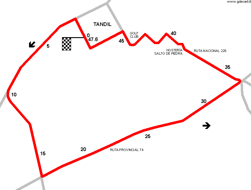
| Distinctive points | Tandil (Centro de la Ciudad) - La Porteña - Curva de Scarminacci - Ruta Provincial 74 - Cruce La Vasconia - Ruta Nacional 226 - Hostería Salto de Piedra - Ingreso Golf Club - Tandil (Centro de la Ciudad) | ||||
| length | 47.8 km | 29.702 mi | (11) | ||
| length | 47.377 km | 29.439 mi | Calculated from aerial photo (*) | (7) | |
Tandil: Circuito Serrano, Vuelta de la Carrettera (1952÷1966)
Due to technical problems, temporarily it’s no longer possible to see the circuits on Google Maps embedded in the current page.
This feature will be restored as soon as I figure out how to do (any help would be appreciated!)
See this track layout with Google Earth
- milermeter.com
(milermeter.com can be used in your browser, without installing anything; Google Earth is a program that must be installed in your computer)
(Map shown here above can show at the same time all eventual layouts drawn. If you want to see only some of them, please go to Google Maps or Google Earth, by clicking on its own link)
| Updates | |||||||
| Date | Track layout | Years | Description by | Map by | Thanks to | Note | |
| November 29th 2010 | Circuito Serrano, Vuelta de la Carrettera | 1952÷1966 | Guido de Carli | Guido de Carli | Luis Alberto González | New | Description with map |
| Not all eventual updates issued in last years are already visible in this list | |||||||


