| ITA - ITALY | |||||||||||||
| CAGLIARI, SANT’ELIA | |||||||||||||
| Not to be confused with | Cagliari - Cagliari - Sassari - Cagliari | ||||||||||||
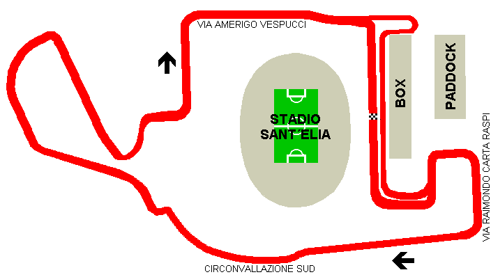
| Description | Street circuit inaugurated with a Euro 3000 series GP on November 10th 2002 (at first scheduled on October 6th 2002). | ||||||||||||
| Location | Stadio Sant’Elia, Cagliari CA - Cagliari - Sardegna | ||||||||||||
| Location | around Sant’Elia football stadium and via Amerigo Vespucci, Cagliari | ||||||||||||
| Latitude - Longitude | + 39°11'58" + 9°08'06" 39.199444 9.135 | ||||||||||||
| UTM Coordinates | X = 511657 - Y = 4338918.158 - Zone 32S | ||||||||||||
| Aerial photo / Map (*) |  OpenStreetMap - Google Maps - Bing Maps - Flash Earth - Wikimapia OpenStreetMap - Google Maps - Bing Maps - Flash Earth - Wikimapia | ||||||||||||
| Altitude AMSL | |||||||||||||
| Inauguration | November 10th 2002 | ||||||||||||
| Closing | November 2003 | ||||||||||||
| Designer | |||||||||||||
| Sources and links (Translation) (**) |
| ||||||||||||
| Cagliari, Sant’Elia | |||||
| Description | |||||
| Years | 2002÷2003 | ||||
| Direction |  Clockwise Clockwise | ||||
 Proposal Proposal |
NO | ||||
| No longer operational | YES | ||||
| Car Circuit | YES | ||||
| Motorbike circuit | |||||
| Type | Street course | ||||
| Inauguration | November 2002 | ||||
| Closing | November 2003 | ||||
| Last update of this page | June 14th 2003 | ||||
| Info last update | |||||
| Designer | |||||
| Distinctive points | via Raimondo Carta Raspi - Circonvallazione Sud - via Amerigo Vespucci | ||||
| length | 2414 m | 7920 ft | 1.5 mi | ||
Cagliari, Sant’Elia