| ITA - ITALY | |||||||||||||
| FRANCOLISE | |||||||||||||
| SORRY, SOME DATA ARE NOT TRANSLATED YET | |||||||||||||
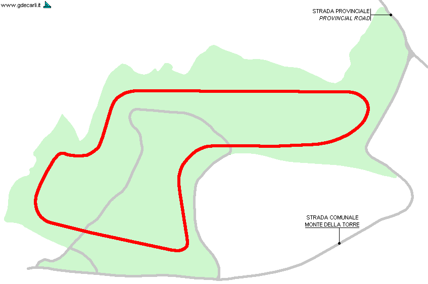
| Description | On December 30th 1981 Francolise Town Council approved the authorization for Scuderia Vesuvio (Vesuvio Racing s.r.l.) to built a permanent track on a 200,917 m² land. At this point only Region authorization was missing, but it seemed there were no problems and according to rumors the foundation stone would have layed within a couple of months. At beginning of 1982 CSAI approved this proposal too: Mr.Bacciagaluppi of Circuit and Safety Subcommission drawn a first draft of track layout (the one shown on my map), that looked immediately good. The ground (so also the circuit) is quote undulating; main straight should have been approx. 400 m - 0.25 mi long and F.1 should have run up to 240 km/h - 150 mph approx. Area where the circuit should have been built is the green one on my map, but ’recently’ (so I think at the end of 1981) 70,000 m² area close to Strada Comunale (Municipal Road) was bought as well. | ||||||||||||
| Location | Francolise CE - Caserta - Campania | ||||||||||||
| Location | |||||||||||||
| Latitude - Longitude (approx) | + 41°11'00" + 14°03'00" (approx) 41.183333 14.05 (approx) | ||||||||||||
| UTM Coordinates (approx) | X = 420324.847 - Y = 4559544.051 - Zone 33T (approx) | ||||||||||||
| Aerial photo / Map (*) |  OpenStreetMap - Google Maps - Bing Maps - Flash Earth - Wikimapia OpenStreetMap - Google Maps - Bing Maps - Flash Earth - Wikimapia | ||||||||||||
| Altitude AMSL | |||||||||||||
| Inauguration | |||||||||||||
| Closing | |||||||||||||
| Designer | Bacciagaluppi | ||||||||||||
| Sources and links (Translation) (**) |
| ||||||||||||
| Francolise | |||||
| Description | |||||
| Years | 1982 | ||||
| Direction | |||||
 Proposal Proposal |
YES
| ||||
| Proposal not developed | YES | ||||
| Car Circuit | YES | ||||
| Motorbike circuit | |||||
| Type | Permanent | ||||
| Inauguration | |||||
| Closing | |||||
| Last update of this page | September 11th 2007 | ||||
| Info last update | January 1982 | ||||
| Designer | |||||
| Distinctive points | |||||
| length (approx) | 2000 m | 6562 ft | 1.243 mi | (2) | |
| Straight length (approx) | 400 m | 1312 ft | 0.249 mi | Longest straight | (2) |
| Total area | 20 hectares | 200917 m² | 49.647 acres | (2) | |
| Total area | 7 hectares | 70000 m² | 17.297 acres | Additional area | (2) |
Francolise
| Updates | |||||||
| Date | Track layout | Years | Description by | Map by | Thanks to | Note | |
| April 25th 2005 | Guido de Carli | Guido de Carli | New | Description with map | |||
| April 5th 2005 | Guido de Carli | New | Description without map | ||||
| Not all eventual updates issued in last years are already visible in this list | |||||||


