| ITA - ITALY | |||||||||||||||||
| PARMA, CITTADELLA | |||||||||||||||||
| Not to be confused with | Parma | ||||||||||||||||
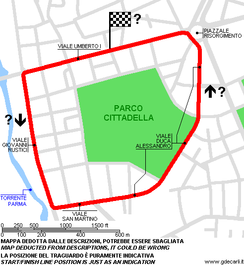
| Description | Street circuit, used at least on June 3rd 1934, probably for a motorbike race. I don’t know if it was used more times, before or after this race; but I know that on June 13th 1947 1st Circuito di Parma (car race) was raced on a 3 km circuit and it could be this one. I’m not sure that the circuit was as shown on my map because I can’t locate exactly Istituto delle Missioni. I have no evidence that start/finish line was in Viale Umberto I and that direction was anticlockwise: these are my assumptions taken from track description. I have no more info. | ||||||||||||||||
| Location | Parma PR - Parma - Emilia Romagna | ||||||||||||||||
| Location | In Parma town center, around Cittadella Park | ||||||||||||||||
| Latitude - Longitude | + 44°47'33" + 10°19'57" 44.7925 10.3325 | ||||||||||||||||
| UTM Coordinates | X = 605399.836 - Y = 4960763.777 - Zone 32T | ||||||||||||||||
| Aerial photo / Map (*) |  OpenStreetMap - Google Maps - Bing Maps - Flash Earth - Wikimapia OpenStreetMap - Google Maps - Bing Maps - Flash Earth - Wikimapia | ||||||||||||||||
| Altitude AMSL | 64 m - 210 ft | ||||||||||||||||
| Inauguration | June 3rd 1934 | ||||||||||||||||
| Closing | 1949 | ||||||||||||||||
| Designer | |||||||||||||||||
| Sources and links (Translation) (**) |
| ||||||||||||||||
| Circuito di Parma | |||||
| Description | Direction to be confirmed | ||||
| Years | 1934÷1938, 1945÷1949 | ||||
| Direction |  Anticlockwise Anticlockwise | ||||
 Proposal Proposal |
NO | ||||
| No longer operational | YES | ||||
| Car Circuit | YES | ||||
| Motorbike circuit | YES | ||||
| Type | Street course | ||||
| Inauguration | June 3rd 1934 | ||||
| Closing | 1949 | ||||
| Last update of this page | October 6th 2008 | ||||
| Info last update | |||||
| Designer | |||||
| Distinctive points | Viale Umberto I (Stradone Martiri della Libertà) - Viale Giovanni Rustici - Istituto delle Missioni - Viale Duca Alessandro - Casino Petitot (Piazzale Risorgimento) - Viale Umberto I (Stradone Martiri della Libertà) | ||||
| length | 3000 m | 9843 ft | 1.864 mi | (1) | |
| length | 3000 m | 9843 ft | 1.864 mi | (3) | |
| length | 2944 m | 9659 ft | 1.83 mi | Calculated from aerial photo (*) | (2) |
Parma 1934÷1938, 1945÷1949 (map deducted from descriptions, it could be wrong)
See this track layout with milermeter.com
(milermeter.com can be used in your browser, without installing anything; Google Earth is a program that must be installed in your computer)
| Updates | |||||||
| Date | Track layout | Years | Description by | Map by | Thanks to | Note | |
| October 6th 2008 | Circuito di Parma | 1934÷1938, 1945÷1949 | Guido de Carli | Update | Description with map | ||
| October 16th 2005 | Circuito di Parma | 1934÷1938, 1945÷1949 | Guido de Carli | Guido de Carli | Pier Paolo Garagnani | New | Description with map |
| Not all eventual updates issued in last years are already visible in this list | |||||||


