| ITA - ITALIA | |||||||||||||||||||||||||||||
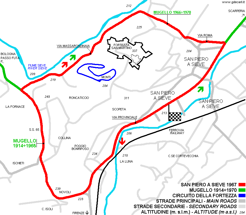
| SAN PIERO A SIEVE, CIRCUITO DELLA FORTEZZA | |||||||||||||||||||||||||||||
| Da non confondere con | Mugello - Mugello (196x) - Mugello, Circuito Stradale - San Piero a Sieve (1967) | ||||||||||||||||||||||||||||
| Descrizione | |||||||||||||||||||||||||||||
| Ubicazione | San Piero a Sieve FI - Firenze - Toscana | ||||||||||||||||||||||||||||
| Ubicazione | sotto alla Fortezza San Martino a San Piero a Sieve | ||||||||||||||||||||||||||||
| Latitudine - Longitudine | + 43°57'45" + 11°18'43" 43.9625 11.311944 | ||||||||||||||||||||||||||||
| Coordinate UTM | X = 685476.662 - Y = 4870306.245 - Fuso 32T | ||||||||||||||||||||||||||||
| Foto aerea / Mappa (*) |  OpenStreetMap - Google Maps - Bing Maps - Flash Earth - Wikimapia OpenStreetMap - Google Maps - Bing Maps - Flash Earth - Wikimapia | ||||||||||||||||||||||||||||
| Altitudine s.l.m. | 248 m - 814 ft | ||||||||||||||||||||||||||||
| Inaugurazione | |||||||||||||||||||||||||||||
| Chiusura | |||||||||||||||||||||||||||||
| Progettista | |||||||||||||||||||||||||||||
| Fonti e link (Traduzioni) (**) |
| ||||||||||||||||||||||||||||
| Circuito della Fortezza | |||||
| Descrizione | Circuito di prova privato, costruito nel 1971 da Lando Baldassini. Subito dopo la partenza c’è una larga curva ad esse, in salita, poi una discesa di circa 350 m, una leggera salita, curva veloce a destra, salita e si torna al traguardo. La mappa è ricavata da una foto aerea e non combacia molto con questa descizione. Si tratta comunque di un circuito impegnativo, pensato per poter imparare la guida veloce (prevista una scuola, probabilmente diretta da «Sangry-Là») e per dare ai preparatori della zona un circuito dove poter provare. Sono inoltre previste delle gare di accelerazione, slalom e inseguimento. Con una vettura come l’Alfa Romeo 1750 GT si possono raggiungere velocità massime intorno a 120-130 km/h (75-80 mph). A parte i test sotto elencati, non ho altre notizie, né so fino a quando il circuito sia stato usato. Ho notizie solo dei seguenti tests:
| ||||
| Anni | 1971÷1972 | ||||
| Rotazione | |||||
 Progetto Progetto |
NO | ||||
| Abbandonato | SÌ | ||||
| Circuito per Auto | SÌ | ||||
| Circuito per Moto | SÌ | ||||
| Tipo Circuito | Stradale permanente | ||||
| Inaugurazione | |||||
| Chiusura | |||||
| Data ultimo aggiornamento archivio | 4 Aprile 2006 | ||||
| Data aggiornamento della notizia | |||||
| Progettista | |||||
| Punti caratteristici | |||||
| Lunghezza (circa) | 1000 m | 3281 ft | 0,621 mi | ||
| Larghezza minima | 9 m | 30 ft | |||
| Larghezza minima | 12 m | 39 ft | |||
| Circuito della Fortezza | |||||
| Descrizione | Dopo un inizio 1972 molto promettente, anche grazie al test della Tecno F.1, il silenzio è tornato sul circuito. Unica eccezione, l’inizio dei lavori di allungamento fino a 3090 m, poi tutto si è nuovamente fermato. Il motivo è la concorrenza del nascente Autodromo del Mugello (in quel periodo ancora in costruzione) che ha distolto l’attenzione da questo circuito. Baldassini ha pensato allora di specializzare il suo impianto per le moto: avrebbe tutte le caratteristiche per essere omologato come circuito internazionale (ad esempio, lunghezza superiore a 3 km - 1,865 mi). All’inizio del 1973 doveva essere discusso lo stanziamento dei fondi necessari per l’asfaltatura della sezione nuova e per la costruzione delle infrastrutture necessarie. Nel giugno 1973 era in calendario una gara nazionale di moto. Una volta terminati tutti i lavori, era prevista l’apertura della pista anche ad altre categorie, ad esempio i Super Kart. Non so se questi lavori siano mai stati eseguiti, dalle foto aeree non sembra. | ||||
| Anni | 1973 | ||||
| Rotazione | |||||
| Progetto |
NO | ||||
| Abbandonato | SÌ | ||||
| Circuito per Auto | SÌ | ||||
| Circuito per Moto | SÌ | ||||
| Tipo Circuito | Stradale permanente | ||||
| Inaugurazione | |||||
| Chiusura | |||||
| Data ultimo aggiornamento archivio | 21 Ottobre 2005 | ||||
| Data aggiornamento della notizia | Febbraio 1973 | ||||
| Progettista | |||||
| Punti caratteristici | |||||
| Lunghezza | 3090 m | 10138 ft | 1,92 mi | (7) | |
San Piero a Sieve, Circuito della Fortezza
| Aggiornamenti | |||||||
| Data | Variante | Anni | Autore testi | Autore mappa | Grazie a | Note | |
| 26 Novembre 2005 | Guido de Carli | Modifica | Descrizione | ||||
| 21 Ottobre 2005 | Guido de Carli | Modifica | Descrizione | ||||
| 18 Agosto 2005 | Guido de Carli | Modifica | Descrizione | ||||
| 6 Marzo 2005 | Guido de Carli | Modifica | Descrizione | ||||
| 23 Febbraio 2005 | Guido de Carli | Guido de Carli | Fr@nk | Nuovo | Descrizione con mappa | ||
| Non tutti gli eventuali aggiornamenti degli anni scorsi sono ancora visibili in questa lista | |||||||


