| LTU - LITHUANIA | |||||||||||||
| VILNIUS | |||||||||||||
| Description | Street circuit, used at least in 2002 (on May 18th-19th and September 7th-8th, if I don’t misunderstand Lithuanian text, that I can’t understand). I don’t know if it was used also before and/or later | ||||||||||||
| Location | Vilnius - Vilniaus apskritis | ||||||||||||
| Location | In North-West side of Vilnius | ||||||||||||
| Latitude - Longitude | + 54°42'22" + 25°12'46" 54.706111 25.212778 | ||||||||||||
| UTM Coordinates | X = 384846.118 - Y = 6063554.63 - Zone 35U | ||||||||||||
| Aerial photo / Map (*) |  OpenStreetMap - Google Maps - Bing Maps - Flash Earth - Wikimapia - New Kosmosnimki OpenStreetMap - Google Maps - Bing Maps - Flash Earth - Wikimapia - New Kosmosnimki | ||||||||||||
| Altitude AMSL | 155 m - 509 ft | ||||||||||||
| Inauguration | |||||||||||||
| Closing | |||||||||||||
| Designer | |||||||||||||
| Sources and links (Translation) (**) |
| ||||||||||||
| Vilnius | |||||
| Description | |||||
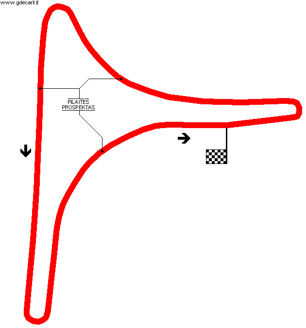
| Years | 2002 | ||||
| Direction |  Anticlockwise Anticlockwise | ||||
 Proposal Proposal |
NO | ||||
| No longer operational | |||||
| Car Circuit | YES | ||||
| Motorbike circuit | |||||
| Type | Street course | ||||
| Inauguration | |||||
| Closing | |||||
| Last update of this page | November 18th 2007 | ||||
| Info last update | 2002 | ||||
| Designer | |||||
| Distinctive points | Pilaitės Prospektas | ||||
| length | 1100 m | 3609 ft | 0.684 mi | (3) | |
Vilnius
Due to technical problems, temporarily it’s no longer possible to see the circuits on Google Maps embedded in the current page.
This feature will be restored as soon as I figure out how to do (any help would be appreciated!)
See this track layout with Google Earth
(milermeter.com can be used in your browser, without installing anything; Google Earth is a program that must be installed in your computer)
(Map shown here above can show at the same time all eventual layouts drawn. If you want to see only some of them, please go to Google Maps or Google Earth, by clicking on its own link)
| Updates | |||||||
| Date | Track layout | Years | Description by | Map by | Thanks to | Note | |
| November 18th 2007 | Guido de Carli | Update | Map | ||||
| June 9th 2006 | Guido de Carli | Roelard Smit | Update | Description | |||
| February 21st 2003 | Guido de Carli | Guido de Carli | New | Description with map | |||
| Not all eventual updates issued in last years are already visible in this list | |||||||


