| LUX - LUXEMBOURG | |||||||||
| FINDEL | |||||||||
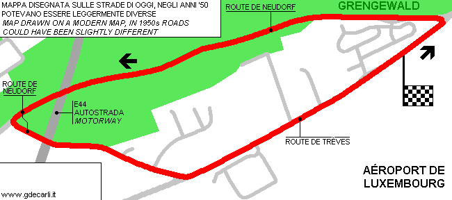
| Description | Street circuit, first used in 1949. I have no more info. My map is based on modern roads; possibly 1950s layout was sightly different. | ||||||||
| Location | Lëtzebuerg / Luxembourg - Luxembourg | ||||||||
| Location | Few km East of Luxembourg City; now it is close to International Luxembourg Airport | ||||||||
| Latitude - Longitude | + 49°37'36" + 6°12'00" 49.626667 6.2 | ||||||||
| UTM Coordinates | X = 297795.45 - Y = 5500888.652 - Zone 32U | ||||||||
| Aerial photo / Map (*) |  OpenStreetMap - Google Maps - Bing Maps - Flash Earth - Wikimapia OpenStreetMap - Google Maps - Bing Maps - Flash Earth - Wikimapia | ||||||||
| Altitude AMSL | |||||||||
| Inauguration | |||||||||
| Closing | |||||||||
| Designer | |||||||||
| Sources and links (Translation) (**) |
| ||||||||
| Findel | |||||
| Description | |||||
| Years | 1949÷... | ||||
| Direction |  Anticlockwise Anticlockwise | ||||
 Proposal Proposal |
NO | ||||
| No longer operational | YES | ||||
| Car Circuit | YES | ||||
| Motorbike circuit | |||||
| Type | Airfield course | ||||
| Inauguration | |||||
| Closing | |||||
| Last update of this page | November 14th 2005 | ||||
| Info last update | |||||
| Designer | |||||
| Distinctive points | Route de Trèves - Route de Neudorf | ||||
| length | 3766 m | 12355 ft | 2.34 mi | ||
Findel
| Updates | |||||||
| Date | Track layout | Years | Description by | Map by | Thanks to | Note | |
| November 12th 2005 | Guido de Carli | Guido de Carli | Barry Boor | New | Description with map | ||
| Not all eventual updates issued in last years are already visible in this list | |||||||


