| NZL - NEW ZEALAND | |||||||||||||||||||||||||
| TERETONGA PARK | |||||||||||||||||||||||||
| Description | Street circuit inaugurated in 1957; on 1966 it was lengthened by changing last corner (this is layout shown on my map). | ||||||||||||||||||||||||
| Location | Invercargill - Southland - South Island | ||||||||||||||||||||||||
| Location | 8 km - 5 mi from Invercargill and near to Otatara, on Domain Road Highway | ||||||||||||||||||||||||
| Latitude - Longitude | - 46°26'35" +168°15'46" -46.443056 168.262778 | ||||||||||||||||||||||||
| UTM Coordinates | X = 289752.557 - Y = 4853083.186 - Zone 59G | ||||||||||||||||||||||||
| Aerial photo / Map (*) |  OpenStreetMap - Google Maps - Bing Maps - Flash Earth - Wikimapia OpenStreetMap - Google Maps - Bing Maps - Flash Earth - Wikimapia | ||||||||||||||||||||||||
| Altitude AMSL | 14 m - 46 ft | ||||||||||||||||||||||||
| Inauguration | |||||||||||||||||||||||||
| Closing | |||||||||||||||||||||||||
| Designer | |||||||||||||||||||||||||
| Sources and links (Translation) (**) |
| ||||||||||||||||||||||||
| Teretonga Park | |||||
| Description | |||||
| Years | 1957÷1966 | ||||
| Direction |  Anticlockwise Anticlockwise | ||||
 Proposal Proposal |
NO | ||||
| No longer operational | |||||
| Car Circuit | YES | ||||
| Motorbike circuit | |||||
| Type | Permanent | ||||
| Inauguration | |||||
| Closing | |||||
| Last update of this page | May 3rd 2008 | ||||
| Info last update | |||||
| Designer | |||||
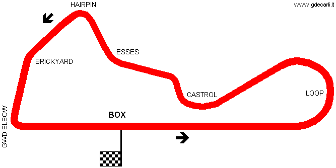
| Distinctive points | Loop - Castrol - Esses - Hairpin - Brickyard | ||||
| length | 2413.8 m | 7919 ft | 1.5 mi | (3) | |
| Teretonga Park | |||||
| Description | |||||
| Years | 1967÷... | ||||
| Direction | Anticlockwise | ||||
| Proposal |
NO | ||||
| No longer operational | |||||
| Car Circuit | YES | ||||
| Motorbike circuit | |||||
| Type | Permanent | ||||
| Inauguration | |||||
| Closing | |||||
| Last update of this page | May 31st 2007 | ||||
| Info last update | |||||
| Designer | |||||
| Distinctive points | Loop - Castrol - Esses - Hairpin - Brickyard - GWD Elbow | ||||
| length | 2575 m | 8448 ft | 1.6 mi | (4) | |
| Teretonga Park | |||||
| Description | |||||
| Years | ...÷2002÷... | ||||
| Direction | Anticlockwise | ||||
| Proposal |
NO | ||||
| No longer operational | |||||
| Car Circuit | YES | ||||
| Motorbike circuit | |||||
| Type | Permanent | ||||
| Inauguration | |||||
| Closing | |||||
| Last update of this page | May 31st 2007 | ||||
| Info last update | |||||
| Designer | |||||
| Distinctive points | |||||
| length | 2570 m | 8432 ft | 1.597 mi | ||
| length | 2620 m | 8596 ft | 1.628 mi | (2) | |
Teretonga Park 1967÷...
| Updates | |||||||
| Date | Track layout | Years | Description by | Map by | Thanks to | Note | |
| May 3rd 2008 | 1957÷1966 | Guido de Carli | Update | Description | |||
| May 30th 2007 | Lorenzo Tommasi | Update | Description | ||||
| April 8th 2004 | 1967÷... | Guido de Carli | Guido de Carli | New | Description with map | ||
| Not all eventual updates issued in last years are already visible in this list | |||||||


