| USA - UNITED STATES | |||||
| CUMBERLAND | |||||
| Description | |||||
| Location | Wiley Ford WV - West Virginia - Southern States | ||||
| Location | |||||
| Latitude - Longitude | + 39°36'52" - 78°46'01" 39.614444 -78.766944 | ||||
| UTM Coordinates | X = 691689.876 - Y = 4387348.174 - Zone 17S | ||||
| Aerial photo / Map (*) |  OpenStreetMap - Google Maps - Bing Maps - Flash Earth - Wikimapia - Microsoft Research Maps - MapQuest OpenStreetMap - Google Maps - Bing Maps - Flash Earth - Wikimapia - Microsoft Research Maps - MapQuest | ||||
| Altitude AMSL | 218 m - 715 ft | ||||
| Inauguration | 1952 | ||||
| Closing | |||||
| Designer | |||||
| Sources and links (Translation) (**) |
| ||||
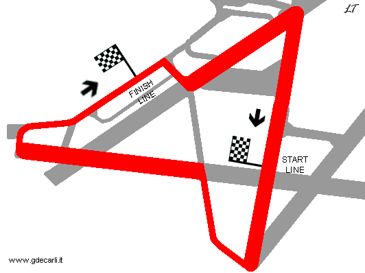
| Cumberland Municipal Airport | |||||
| Description | |||||
| Years | 1952÷196x | ||||
| Direction |  Clockwise Clockwise | ||||
 Proposal Proposal |
NO | ||||
| No longer operational | YES | ||||
| Car Circuit | YES | ||||
| Motorbike circuit | |||||
| Type | Airfield course | ||||
| Inauguration | 1952 | ||||
| Closing | |||||
| Last update of this page | May 17th 2003 | ||||
| Info last update | |||||
| Designer | |||||
| Distinctive points | |||||
| length | 2575 m | 8448 ft | 1.6 mi | (1) | |
Cumberland
Due to technical problems, temporarily it’s no longer possible to see the circuits on Google Maps embedded in the current page.
This feature will be restored as soon as I figure out how to do (any help would be appreciated!)
See this track layout with Google Earth
(milermeter.com can be used in your browser, without installing anything; Google Earth is a program that must be installed in your computer)
(Map shown here above can show at the same time all eventual layouts drawn. If you want to see only some of them, please go to Google Maps or Google Earth, by clicking on its own link)
| Updates | |||||||
| Date | Track layout | Years | Description by | Map by | Thanks to | Note | |
| April 26th 2007 | Lorenzo Tommasi | Update | Map | ||||
| May 16th 2003 | Guido de Carli | New | Description | ||||
| Not all eventual updates issued in last years are already visible in this list | |||||||


