| ARG - ARGENTINA | |||||||||
| AVELLANEDA | |||||||||
| Description | |||||||||
| Location | Avellaneda S - Santa Fé - Centro | ||||||||
| Location | |||||||||
| Latitude - Longitude (approx) | - 29°07'00" - 59°40'00" (approx) -29.116667 -59.666667 (approx) | ||||||||
| UTM Coordinates (approx) | X = 240509.332 - Y = 6776148.882 - Zone 21J (approx) | ||||||||
| Aerial photo / Map (*) |  OpenStreetMap - Google Maps - Bing Maps - Flash Earth - Wikimapia OpenStreetMap - Google Maps - Bing Maps - Flash Earth - Wikimapia | ||||||||
| Altitude AMSL (approx) | 50 m - 164 ft (approx) | ||||||||
| Inauguration | March 24th 1985 | ||||||||
| Closing | |||||||||
| Designer | |||||||||
| Sources and links (Translation) (**) |
| ||||||||
| Autódromo de Avellaneda | |||||
| Description | |||||
| Years | |||||
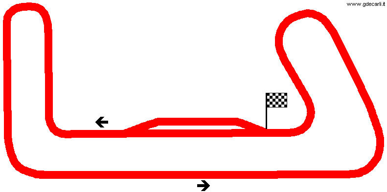
| Direction |  Anticlockwise Anticlockwise | ||||
 Proposal Proposal |
NO | ||||
| No longer operational | |||||
| Car Circuit | YES | ||||
| Motorbike circuit | |||||
| Type | Permanent | ||||
| Inauguration | March 24th 1985 | ||||
| Closing | |||||
| Last update of this page | June 18th 2007 | ||||
| Info last update | |||||
| Designer | |||||
| Distinctive points | |||||
| length | 2114 m | 6936 ft | 1.314 mi | (1) | |
Avellaneda
| Updates | |||||||
| Date | Track layout | Years | Description by | Map by | Thanks to | Note | |
| January 15th 2005 | Guido de Carli | New | Description with map | ||||
| September 15th 2004 | Guido de Carli | New | Description | ||||
| Not all eventual updates issued in last years are already visible in this list | |||||||


