| ARG - ARGENTINA | |||||||||||||||||||||||||||||||
| ROSARIO, PARQUE INDIPENDENCIA | |||||||||||||||||||||||||||||||
| Not to be confused with | Rosario, Costanera - Rosario, Fangio - Rosario, Las Paralelas (Circunvalación) - Vuelta de Rosario | ||||||||||||||||||||||||||||||
| Description | |||||||||||||||||||||||||||||||
| Location |
Rosario S - Santa Fé - Centro Parque Indipendencia (= Indipendence Park), Rosario |
||||||||||||||||||||||||||||||
| Latitude - Longitude |
- 32°57'34" - 60°39'37" -32.959444 -60.660278 |
||||||||||||||||||||||||||||||
| UTM Coordinates | X = 718692.016 - Y = 6350778.971 - Zone 20H | ||||||||||||||||||||||||||||||
| Aerial photo / Map (*) |
OpenStreetMap - Google Maps - Bing Maps - Zoom Earth - Wikimapia
|
||||||||||||||||||||||||||||||
| Altitude AMSL | 26 m - 85 ft | ||||||||||||||||||||||||||||||
| Inauguration | 1947 | ||||||||||||||||||||||||||||||
| Closing | January 30th 1966 | ||||||||||||||||||||||||||||||
| Designer | |||||||||||||||||||||||||||||||
| Sources and links (Translation) (**) |
|
||||||||||||||||||||||||||||||
| Parque Indipendencia | |||||
| Description | |||||
| Years | 1947 | ||||
| Direction |
Clockwise
|
||||
Proposal
|
NO | ||||
| No longer operational | YES | ||||
| Car Circuit | YES | ||||
| Motorbike circuit | |||||
| Type | Street course | ||||
| Inauguration | 1947 | ||||
| Closing | 1947 | ||||
| Last update of this page | October 4th 2007 | ||||
| Info last update | |||||
| Designer | |||||
| Distinctive points | |||||
| length | 2820 m | 9252 ft | 1.752 mi | (4) | |
| Parque Indipendencia | |||||
| Description | |||||
| Years | 1948÷1950 | ||||
| Direction |
Clockwise
|
||||
Proposal
|
NO | ||||
| No longer operational | YES | ||||
| Car Circuit | YES | ||||
| Motorbike circuit | |||||
| Type | Street course | ||||
| Inauguration | 1948 | ||||
| Closing | 1950 | ||||
| Last update of this page | July 22nd 2002 | ||||
| Info last update | |||||
| Designer | |||||
| Distinctive points | |||||
| length | 2811 m | 9222 ft | 1.747 mi | (5) | |
| Parque Indipendencia | |||||
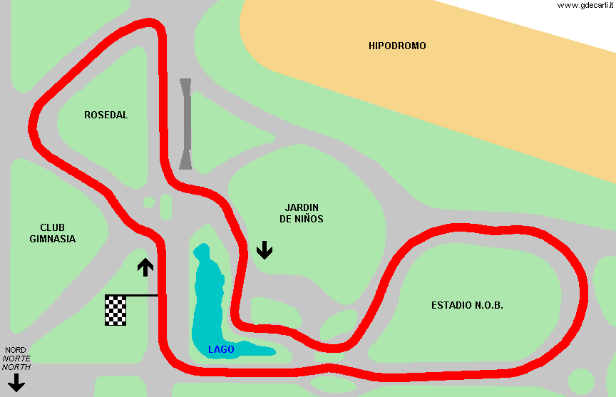
| Description | Street circuit used at list for Formula 3 Gran Premio Internacional Ciudad de Rosario ACINDAR S.A. on January 30th 1966. Track layout is very similar to the one used at least in 1948÷1950 | ||||
| Years | 1966 | ||||
| Direction |
Clockwise
|
||||
Proposal
|
NO | ||||
| No longer operational | YES | ||||
| Car Circuit | YES | ||||
| Motorbike circuit | |||||
| Type | Street course | ||||
| Inauguration | January 30th 1966 | ||||
| Closing | January 30th 1966 | ||||
| Last update of this page | October 4th 2007 | ||||
| Info last update | |||||
| Designer | |||||
| Distinctive points | |||||
| length | 2765 m | 9072 ft | 1.718 mi | ||
Rosario, Parque Indipendencia 1966

| Updates | |||||||
| Date | Track layout | Years | Description by | Map by | Thanks to | Note | |
| November 23rd 2004 | Parque Indipendencia | 1966 | Guido de Carli | Guido de Carli | New | Description with map | |
| April 22nd 2004 | Parque Indipendencia | 1948÷1950 | Guido de Carli | New | Description | ||
| Not all eventual updates issued in last years are already visible in this list | |||||||